Mulauin geodata
Mulauin (Calabarzon) is a populated place; located in Philippines in Asia/Manila (GMT+8) time zone. With population of 2,631 people, there are 3061 cities with bigger population in this country. Compared to other cities in Philippines, 66.8% of cities are located further ↓South; 76% of cities are located further →East and 90.3% of cities have lower elevation than Mulauin. Note1


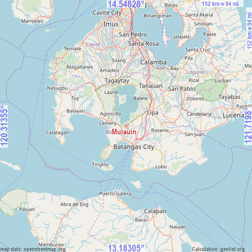
Mulauin GPS coordinates[2]
13° 52' 0.012" North, 121° 1' 0.012" East
| Map corner | latitude | longitude |
|---|---|---|
| Upper-left | 14.54828°, | 120.31355° |
| Center: | 13.86667°, | 121.01667° |
| Lower-right: | 13.18305°, | 121.7198° |
| Map W x H: | 151.8×151.8 km | = 94.3×94.3mi |
| max Lat: | 20.78733° ⇑33.2% North |
| Mulauin: | 13.86667° |
| min Lat: | ⇓66.8% South 4.65442° |
| min Long | Mulauin | max Long |
| 117.04868° | 121.01667° | 126.58417° |
| W 24%⇐ | ⇒76% E |
Elevation
Elevation of Mulauin is 234 m = 768 ft, and this is 146.1 m = 479 ft above average elevation for this country.
| Max E: |
2262 m = 7421 ft | 9.7% |
| Mulauin | 234 m 768 ft | |
| Avg. | 87.9 m = 288 ft | |
Min E: |
-2 m = -7 ft | 90.3% |
See also: Philippines elevation on elevation.city.
Geographical zone
Mulauin is located in North Torrid zone (between Equator and Tropic of Cancer). Distance of this Northern Tropic circle is 1064.1 km =661.2 mi to North.| Distance of | km | miles | from Mulauin |
|---|---|---|---|
| North Pole | 8465.2 | 5260 | to North |
| Arctic Circle | 5859.3 | 3640.8 | to North |
| Tropic Cancer | 1064.1 | 661.2 | to North |
| Equator | 1541.8 | 958 | to South |


Nearby cities:
15 places around Mulauin: (largest is in red/bold)
• Alitagtag
1.4 km =0.9 mi,  259°
259°
• Balagtasin
8.7 km =5.4 mi,  63°
63°
• Bauan
8.4 km =5.2 mi,  186°
186°
• Bolo
9.3 km =5.8 mi,  203°
203°
• Bukal
9 km =5.6 mi,  111°
111°
• Calumpang
5.2 km =3.2 mi,  238°
238°
• Cuenca
5.5 km =3.4 mi,  44°
44°
• Inicbulan
6.3 km =3.9 mi,  214°
214°
• Mozon
3.3 km =2.1 mi, 242°
• San Jose
7.4 km =4.6 mi, 257°
• San Jose
9.6 km =6 mi,  82°
82°
• San Pascual
6.3 km =3.9 mi,  174°
174°
• Santa Teresita
3.8 km =2.4 mi,  269°
269°
• Sinala
8.2 km =5.1 mi, 213°
• Taysan
8.7 km =5.4 mi,  87°
87°
Sources, notices
• [Note1] Compared only with cities in Philippines existing in our database
• [Src1] Map data: © OpenStreetMap contributors (CC-BY-SA)
• [Src2] Other city data from geonames.org with taken over terms of usage.
• [Src3] Geographical zone / Annual Mean Temperature by Robert A. Rohde @ Wikipedia
