Castañas geodata
Castañas (Calabarzon) is a populated place; located in Philippines in Asia/Manila (GMT+8) time zone. With population of 9,040 people, there are 681 cities with bigger population in this country. Compared to other cities in Philippines, 67% of cities are located further ↓South; 65.8% of cities are located further →East and 97.1% of cities have higher elevation than Castañas. Note1


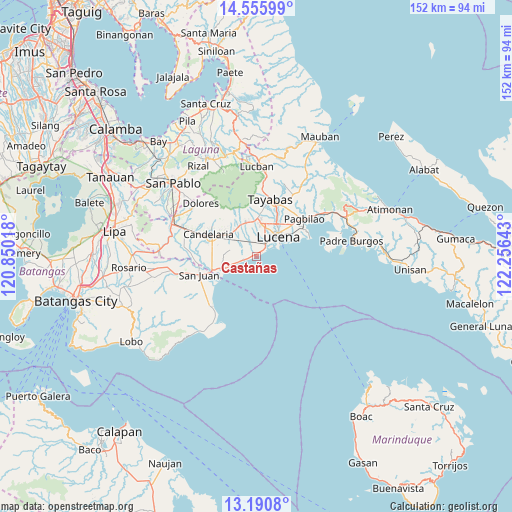
Castañas GPS coordinates[2]
13° 52' 27.84" North, 121° 33' 11.88" East
| Map corner | latitude | longitude |
|---|---|---|
| Upper-left | 14.55599°, | 120.85018° |
| Center: | 13.8744°, | 121.5533° |
| Lower-right: | 13.1908°, | 122.25643° |
| Map W x H: | 151.8×151.8 km | = 94.3×94.3mi |
| max Lat: | 20.78733° ⇑33% North |
| Castañas: | 13.8744° |
| min Lat: | ⇓67% South 4.65442° |
| min Long | Castañas | max Long |
| 117.04868° | 121.5533° | 126.58417° |
| W 34.2%⇐ | ⇒65.8% E |
Elevation
Elevation of Castañas is 4 m = 13 ft, and this is 83.9 m = 275 ft below average elevation for this country.
| Max E: |
2262 m = 7421 ft | 97.1% |
| Avg. | 87.9 m = 288 ft | |
| Castañas | 4 m = 13 ft | |
Min E: |
-2 m = -7 ft | 2.9% |
See also: Philippines elevation on elevation.city.
Geographical zone
Castañas is located in North Torrid zone (between Equator and Tropic of Cancer). Distance of this Northern Tropic circle is 1063.2 km =660.6 mi to North.| Distance of | km | miles | from Castañas |
|---|---|---|---|
| North Pole | 8464.4 | 5259.5 | to North |
| Arctic Circle | 5858.5 | 3640.3 | to North |
| Tropic Cancer | 1063.2 | 660.6 | to North |
| Equator | 1542.7 | 958.6 | to South |


Nearby cities:
15 places around Castañas: (largest is in red/bold)
• Bignay Uno
7.1 km =4.4 mi,  261°
261°
• Bukal
5.2 km =3.2 mi,  326°
326°
• Calumpang
12.8 km =8 mi,  358°
358°
• Candelaria
15.4 km =9.6 mi,  294°
294°
• Concepcion Ibaba
11.3 km =7 mi,  298°
298°
• Guisguis
3.7 km =2.3 mi,  268°
268°
• Isabang
9.4 km =5.8 mi,  11°
11°
• Janagdong
5.4 km =3.4 mi,  306°
306°
• Lucena
9.4 km =5.8 mi,  47°
47°
• Malabanban Norte
15.4 km =9.6 mi, 300°
• Montecillo
8.6 km =5.3 mi,  282°
282°
• Poctol
13.4 km =8.3 mi,  243°
243°
• Santa Catalina Sur
13.2 km =8.2 mi, 269°
• Sariaya
10.2 km =6.3 mi,  343°
343°
• Tipaz
14.8 km =9.2 mi,  249°
249°
Sources, notices
• [Note1] Compared only with cities in Philippines existing in our database
• [Src1] Map data: © OpenStreetMap contributors (CC-BY-SA)
• [Src2] Other city data from geonames.org with taken over terms of usage.
• [Src3] Geographical zone / Annual Mean Temperature by Robert A. Rohde @ Wikipedia
