Bukal geodata
Bukal (Calabarzon) is a populated place; located in Philippines in Asia/Manila (GMT+8) time zone. With population of 3,254 people, there are 2253 cities with bigger population in this country. Compared to other cities in Philippines, 67.7% of cities are located further ↓South; 66.1% of cities are located further →East and 71.2% of cities have lower elevation than Bukal. Note1


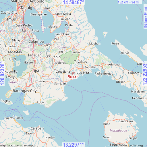
Bukal GPS coordinates[2]
13° 54' 47.52" North, 121° 31' 35.04" East
| Map corner | latitude | longitude |
|---|---|---|
| Upper-left | 14.59467°, | 120.82328° |
| Center: | 13.9132°, | 121.5264° |
| Lower-right: | 13.22971°, | 122.22953° |
| Map W x H: | 151.8×151.8 km | = 94.3×94.3mi |
| max Lat: | 20.78733° ⇑32.3% North |
| Bukal: | 13.9132° |
| min Lat: | ⇓67.7% South 4.65442° |
| min Long | Bukal | max Long |
| 117.04868° | 121.5264° | 126.58417° |
| W 33.9%⇐ | ⇒66.1% E |
Elevation
Elevation of Bukal is 55 m = 180 ft, and this is 32.9 m = 108 ft below average elevation for this country.
| Max E: |
2262 m = 7421 ft | 28.8% |
| Avg. | 87.9 m = 288 ft | |
| Bukal | 55 m = 180 ft | |
Min E: |
-2 m = -7 ft | 71.2% |
See also: Philippines elevation on elevation.city.
Geographical zone
Bukal is located in North Torrid zone (between Equator and Tropic of Cancer). Distance of this Northern Tropic circle is 1058.9 km =658 mi to North.| Distance of | km | miles | from Bukal |
|---|---|---|---|
| North Pole | 8460.1 | 5256.9 | to North |
| Arctic Circle | 5854.2 | 3637.6 | to North |
| Tropic Cancer | 1058.9 | 658 | to North |
| Equator | 1547 | 961.3 | to South |


Nearby cities:
15 places around Bukal: (largest is in red/bold)
• Bignay Uno
6.8 km =4.2 mi,  217°
217°
• Calumpang
8.9 km =5.5 mi,  16°
16°
• Candelaria
11.3 km =7 mi,  280°
280°
• Castañas
5.2 km =3.2 mi,  146°
146°
• Concepcion Ibaba
7.1 km =4.4 mi, 278°
• Guisguis
4.5 km =2.8 mi,  190°
190°
• Isabang
6.8 km =4.2 mi,  44°
44°
• Janagdong
1.8 km =1.1 mi,  232°
232°
• Lucena
10 km =6.2 mi,  78°
78°
• Malabanban Norte
10.9 km =6.8 mi,  289°
289°
• Mamala
11.6 km =7.2 mi,  354°
354°
• Masalukot Uno
12.5 km =7.8 mi, 291°
• Montecillo
6 km =3.7 mi,  245°
245°
• Santa Catalina Sur
11.2 km =7 mi, 246°
• Sariaya
5.5 km =3.4 mi,  0°
0°
Sources, notices
• [Note1] Compared only with cities in Philippines existing in our database
• [Src1] Map data: © OpenStreetMap contributors (CC-BY-SA)
• [Src2] Other city data from geonames.org with taken over terms of usage.
• [Src3] Geographical zone / Annual Mean Temperature by Robert A. Rohde @ Wikipedia
