Dicamay geodata
Dicamay (Cagayan Valley) is a populated place; located in Philippines in Asia/Manila (GMT+8) time zone. With population of 2,370 people, there are 3517 cities with bigger population in this country. Compared to other cities in Philippines, 92.1% of cities are located further ↓South; 60.2% of cities are located further →East and 85.4% of cities have lower elevation than Dicamay. Note1
Administrative division(s):
- Level 1: Cagayan Valley
- Level 2: Province of Isabela
- Level 3: San Mariano


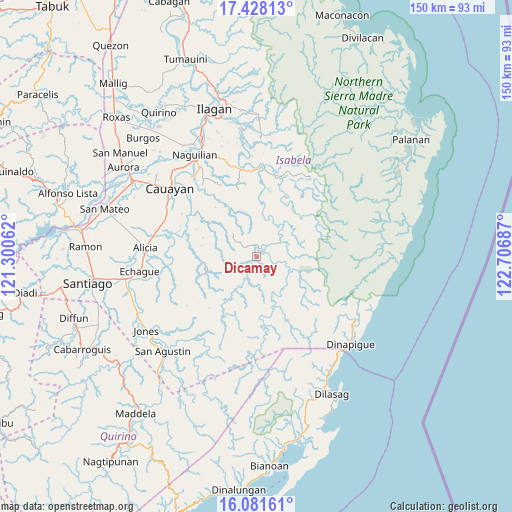
Dicamay GPS coordinates[2]
16° 45' 21.816" North, 122° 0' 13.464" East
| Map corner | latitude | longitude |
|---|---|---|
| Upper-left | 17.42813°, | 121.30062° |
| Center: | 16.75606°, | 122.00374° |
| Lower-right: | 16.08161°, | 122.70687° |
| Map W x H: | 149.7×149.7 km | = 93×93mi |
| max Lat: | 20.78733° ⇑7.9% North |
| Dicamay: | 16.75606° |
| min Lat: | ⇓92.1% South 4.65442° |
| min Long | Dicamay | max Long |
| 117.04868° | 122.00374° | 126.58417° |
| W 39.8%⇐ | ⇒60.2% E |
Elevation
Elevation of Dicamay is 144 m = 472 ft, and this is 56.1 m = 184 ft above average elevation for this country.
| Max E: |
2262 m = 7421 ft | 14.6% |
| Dicamay | 144 m 472 ft | |
| Avg. | 87.9 m = 288 ft | |
Min E: |
-2 m = -7 ft | 85.4% |
See also: Philippines elevation on elevation.city.
Geographical zone
Dicamay is located in North Torrid zone (between Equator and Tropic of Cancer). Distance of this Northern Tropic circle is 742.8 km =461.6 mi to North.| Distance of | km | miles | from Dicamay |
|---|---|---|---|
| North Pole | 8144 | 5060.4 | to North |
| Arctic Circle | 5538.1 | 3441.2 | to North |
| Tropic Cancer | 742.8 | 461.6 | to North |
| Equator | 1863.1 | 1157.7 | to South |


Nearby cities:
15 places around Dicamay: (largest is in red/bold)
• Angadanan
27.2 km =16.9 mi,  269°
269°
• Benito Soliven
25.5 km =15.8 mi,  349°
349°
• Burgos
29.8 km =18.5 mi,  284°
284°
• Daragutan
27.3 km =17 mi,  6°
6°
• Gappal
21.3 km =13.2 mi,  294°
294°
• Malasin
24 km =14.9 mi, 282°
• Maluno Sur
27.3 km =17 mi, 351°
• Minallo
30.2 km =18.8 mi,  328°
328°
• Minante Segundo
30.4 km =18.9 mi,  302°
302°
• Minuri
29.5 km =18.3 mi,  212°
212°
• San Guillermo
20.9 km =13 mi,  260°
260°
• San Luis
29.8 km =18.5 mi,  321°
321°
• San Mariano
25.2 km =15.7 mi,  2°
2°
• Sillawit
29.1 km =18.1 mi, 296°
• Yeban Norte
30.3 km =18.8 mi, 347°
Sources, notices
• [Note1] Compared only with cities in Philippines existing in our database
• [Src1] Map data: © OpenStreetMap contributors (CC-BY-SA)
• [Src2] Other city data from geonames.org with taken over terms of usage.
• [Src3] Geographical zone / Annual Mean Temperature by Robert A. Rohde @ Wikipedia
