Mindupok geodata
Mindupok (Soccsksargen) is a populated place; located in Philippines in Asia/Manila (GMT+8) time zone. With population of 3,437 people, there are 2110 cities with bigger population in this country. Compared to other cities in Philippines, 97.4% of cities are located further ↑North; 77.8% of cities are located further ←West and 85.4% of cities have higher elevation than Mindupok. Note1


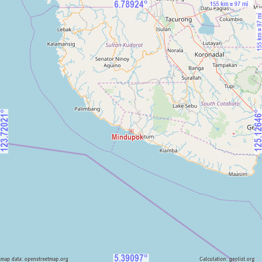
Mindupok GPS coordinates[2]
6° 5' 26.016" North, 124° 25' 23.988" East
| Map corner | latitude | longitude |
|---|---|---|
| Upper-left | 6.78924°, | 123.72021° |
| Center: | 6.09056°, | 124.42333° |
| Lower-right: | 5.39097°, | 125.12646° |
| Map W x H: | 155.5×155.5 km | = 96.6×96.6mi |
| max Lat: | 20.78733° ⇑97.4% North |
| Mindupok: | 6.09056° |
| min Lat: | ⇓2.6% South 4.65442° |
| min Long | Mindupok | max Long |
| 117.04868° | 124.42333° | 126.58417° |
| W 77.8%⇐ | ⇒22.2% E |
Elevation
Elevation of Mindupok is 8 m = 26 ft, and this is 79.9 m = 262 ft below average elevation for this country.
| Max E: |
2262 m = 7421 ft | 85.4% |
| Avg. | 87.9 m = 288 ft | |
| Mindupok | 8 m = 26 ft | |
Min E: |
-2 m = -7 ft | 14.6% |
See also: Philippines elevation on elevation.city.
Geographical zone
Mindupok is located in North Torrid zone (between Equator and Tropic of Cancer). Distance of Equator is 677.2 km =420.8 mi to South.| Distance of | km | miles | from Mindupok |
|---|---|---|---|
| North Pole | 9329.9 | 5797.3 | to North |
| Arctic Circle | 6724 | 4178.1 | to North |
| Tropic Cancer | 1928.7 | 1198.4 | to North |
| Equator | 677.2 | 420.8 | to South |


Nearby cities:
15 places around Mindupok: (largest is in red/bold)
• Buadtasan
23 km =14.3 mi,  114°
114°
• Colongulo
43 km =26.7 mi,  50°
50°
• Dahay
46.4 km =28.8 mi,  43°
43°
• Kiamba
24.9 km =15.5 mi,  116°
116°
• Kling
37.4 km =23.2 mi, 116°
• Lake Sebu
35.1 km =21.8 mi,  64°
64°
• Lumuyon
44.7 km =27.8 mi, 115°
• Maan
38.7 km =24 mi, 116°
• Mabay
6 km =3.7 mi,  127°
127°
• Maguling
2.3 km =1.4 mi,  282°
282°
• Maitum
10.1 km =6.3 mi, 124°
• Malisbeng
8.3 km =5.2 mi,  293°
293°
• Nalus
19.9 km =12.4 mi, 115°
• Palimbang
29.1 km =18.1 mi,  297°
297°
• Tambilil
30.8 km =19.1 mi, 117°
Sources, notices
• [Note1] Compared only with cities in Philippines existing in our database
• [Src1] Map data: © OpenStreetMap contributors (CC-BY-SA)
• [Src2] Other city data from geonames.org with taken over terms of usage.
• [Src3] Geographical zone / Annual Mean Temperature by Robert A. Rohde @ Wikipedia
