Malisbeng geodata
Malisbeng (Soccsksargen) is a populated place; located in Philippines in Asia/Manila (GMT+8) time zone. With population of 4,452 people, there are 1519 cities with bigger population in this country. Compared to other cities in Philippines, 97.3% of cities are located further ↑North; 76.7% of cities are located further ←West and 85.4% of cities have higher elevation than Malisbeng. Note1
Administrative division(s):
- Level 1: Soccsksargen
- Level 2: Province of Sultan Kudarat
- Level 3: Palimbang


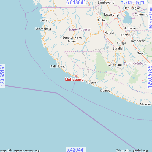
Malisbeng GPS coordinates[2]
6° 7' 12" North, 124° 21' 16.992" East
| Map corner | latitude | longitude |
|---|---|---|
| Upper-left | 6.81864°, | 123.6516° |
| Center: | 6.12°, | 124.35472° |
| Lower-right: | 5.42044°, | 125.05785° |
| Map W x H: | 155.5×155.5 km | = 96.6×96.6mi |
| max Lat: | 20.78733° ⇑97.3% North |
| Malisbeng: | 6.12° |
| min Lat: | ⇓2.7% South 4.65442° |
| min Long | Malisbeng | max Long |
| 117.04868° | 124.35472° | 126.58417° |
| W 76.7%⇐ | ⇒23.3% E |
Elevation
Elevation of Malisbeng is 8 m = 26 ft, and this is 79.9 m = 262 ft below average elevation for this country.
| Max E: |
2262 m = 7421 ft | 85.4% |
| Avg. | 87.9 m = 288 ft | |
| Malisbeng | 8 m = 26 ft | |
Min E: |
-2 m = -7 ft | 14.6% |
See also: Philippines elevation on elevation.city.
Geographical zone
Malisbeng is located in North Torrid zone (between Equator and Tropic of Cancer). Distance of Equator is 680.5 km =422.8 mi to South.| Distance of | km | miles | from Malisbeng |
|---|---|---|---|
| North Pole | 9326.6 | 5795.3 | to North |
| Arctic Circle | 6720.7 | 4176 | to North |
| Tropic Cancer | 1925.4 | 1196.4 | to North |
| Equator | 680.5 | 422.8 | to South |


Nearby cities:
15 places around Malisbeng: (largest is in red/bold)
• Buadtasan
31.3 km =19.4 mi,  114°
114°
• Colongulo
47.3 km =29.4 mi,  59°
59°
• Kiamba
33.1 km =20.6 mi,  115°
115°
• Kling
45.6 km =28.3 mi, 116°
• Kulaman
48 km =29.8 mi,  322°
322°
• Lake Sebu
41 km =25.5 mi,  73°
73°
• Maan
46.9 km =29.1 mi, 116°
• Mabay
14.2 km =8.8 mi, 119°
• Maguling
6.1 km =3.8 mi, 117°
• Maitum
18.3 km =11.4 mi, 119°
• Manuel Roxas
49.6 km =30.8 mi,  43°
43°
• Mindupok
8.3 km =5.2 mi, 113°
• Nalus
28.2 km =17.5 mi, 115°
• Palimbang
20.9 km =13 mi,  298°
298°
• Tambilil
39 km =24.2 mi, 116°
Sources, notices
• [Note1] Compared only with cities in Philippines existing in our database
• [Src1] Map data: © OpenStreetMap contributors (CC-BY-SA)
• [Src2] Other city data from geonames.org with taken over terms of usage.
• [Src3] Geographical zone / Annual Mean Temperature by Robert A. Rohde @ Wikipedia
