Jovellar geodata
Jovellar (Bicol) is a seat of a third-order administrative division; located in Philippines in Asia/Manila (GMT+8) time zone. With population of 3,936 people, there are 1767 cities with bigger population in this country. Compared to other cities in Philippines, 58% of cities are located further ↓South; 63.9% of cities are located further ←West and 59.5% of cities have lower elevation than Jovellar. Note1


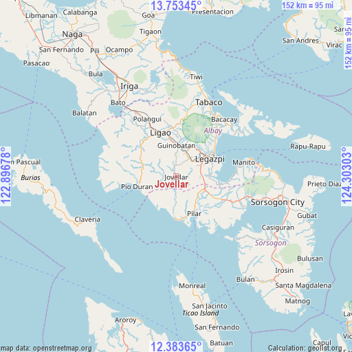
Jovellar GPS coordinates[2]
13° 4' 10.2" North, 123° 35' 59.64" East
| Map corner | latitude | longitude |
|---|---|---|
| Upper-left | 13.75345°, | 122.89678° |
| Center: | 13.0695°, | 123.5999° |
| Lower-right: | 12.38365°, | 124.30303° |
| Map W x H: | 152.3×152.3 km | = 94.6×94.6mi |
| max Lat: | 20.78733° ⇑42% North |
| Jovellar: | 13.0695° |
| min Lat: | ⇓58% South 4.65442° |
| min Long | Jovellar | max Long |
| 117.04868° | 123.5999° | 126.58417° |
| W 63.9%⇐ | ⇒36.1% E |
Elevation
Elevation of Jovellar is 33 m = 108 ft, and this is 54.9 m = 180 ft below average elevation for this country.
| Max E: |
2262 m = 7421 ft | 40.5% |
| Avg. | 87.9 m = 288 ft | |
| Jovellar | 33 m = 108 ft | |
Min E: |
-2 m = -7 ft | 59.5% |
See also: Philippines elevation on elevation.city.
Geographical zone
Jovellar is located in North Torrid zone (between Equator and Tropic of Cancer). Distance of this Northern Tropic circle is 1152.7 km =716.3 mi to North.| Distance of | km | miles | from Jovellar |
|---|---|---|---|
| North Pole | 8553.9 | 5315.1 | to North |
| Arctic Circle | 5948 | 3695.9 | to North |
| Tropic Cancer | 1152.7 | 716.3 | to North |
| Equator | 1453.2 | 903 | to South |


Nearby cities:
15 places around Jovellar: (largest is in red/bold)
• Aanislag
11.2 km =7 mi,  86°
86°
• Abucay
11.1 km =6.9 mi,  151°
151°
• Baligang
10.5 km =6.5 mi,  26°
26°
• Barayong
13.1 km =8.1 mi,  74°
74°
• Bascaron
11.4 km =7.1 mi, 71°
• Camalig
13.8 km =8.6 mi, 25°
• Cotmon
8.7 km =5.4 mi,  52°
52°
• Guinobatan
13.5 km =8.4 mi,  359°
359°
• Lacag
13 km =8.1 mi,  42°
42°
• Malabog
14.9 km =9.3 mi, 38°
• Mauraro
8.9 km =5.5 mi, 356°
• Putiao
13.6 km =8.5 mi,  114°
114°
• Salvacion
1.8 km =1.1 mi,  99°
99°
• Tinago
13.8 km =8.6 mi,  23°
23°
• Villahermosa
12.6 km =7.8 mi, 102°
Sources, notices
• [Note1] Compared only with cities in Philippines existing in our database
• [Src1] Map data: © OpenStreetMap contributors (CC-BY-SA)
• [Src2] Other city data from geonames.org with taken over terms of usage.
• [Src3] Geographical zone / Annual Mean Temperature by Robert A. Rohde @ Wikipedia
