Jamindan geodata
Jamindan (Western Visayas) is a seat of a third-order administrative division; located in Philippines in Asia/Manila (GMT+8) time zone. With population of 2,162 people, there are 3966 cities with bigger population in this country. Compared to other cities in Philippines, 52.5% of cities are located further ↑North; 54.9% of cities are located further →East and 61.5% of cities have lower elevation than Jamindan. Note1


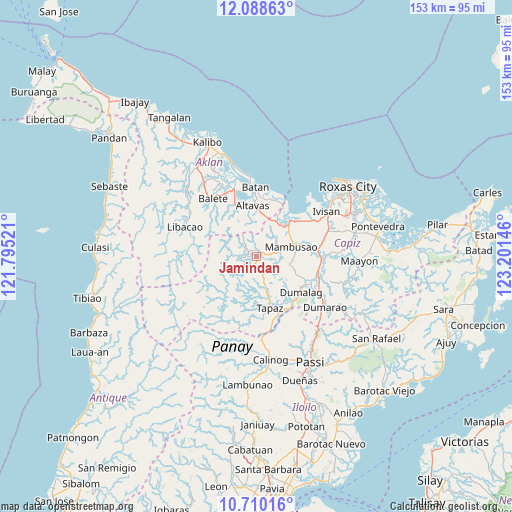
Jamindan GPS coordinates[2]
11° 24' 0.828" North, 122° 29' 53.988" East
| Map corner | latitude | longitude |
|---|---|---|
| Upper-left | 12.08863°, | 121.79521° |
| Center: | 11.40023°, | 122.49833° |
| Lower-right: | 10.71016°, | 123.20146° |
| Map W x H: | 153.3×153.3 km | = 95.3×95.3mi |
| max Lat: | 20.78733° ⇑52.5% North |
| Jamindan: | 11.40023° |
| min Lat: | ⇓47.5% South 4.65442° |
| min Long | Jamindan | max Long |
| 117.04868° | 122.49833° | 126.58417° |
| W 45.1%⇐ | ⇒54.9% E |
Elevation
Elevation of Jamindan is 36 m = 118 ft, and this is 51.9 m = 170 ft below average elevation for this country.
| Max E: |
2262 m = 7421 ft | 38.5% |
| Avg. | 87.9 m = 288 ft | |
| Jamindan | 36 m = 118 ft | |
Min E: |
-2 m = -7 ft | 61.5% |
See also: Philippines elevation on elevation.city.
Geographical zone
Jamindan is located in North Torrid zone (between Equator and Tropic of Cancer). Distance of Equator is 1267.6 km =787.6 mi to South.| Distance of | km | miles | from Jamindan |
|---|---|---|---|
| North Pole | 8739.5 | 5430.5 | to North |
| Arctic Circle | 6133.6 | 3811.2 | to North |
| Tropic Cancer | 1338.3 | 831.6 | to North |
| Equator | 1267.6 | 787.6 | to South |


Nearby cities:
15 places around Jamindan: (largest is in red/bold)
• Ag-ambulong
3.7 km =2.3 mi,  161°
161°
• Bilao
11.8 km =7.3 mi,  34°
34°
• Bula
9.3 km =5.8 mi,  55°
55°
• Burias
7.6 km =4.7 mi,  47°
47°
• Candelaria
12.6 km =7.8 mi,  167°
167°
• Damayan
12 km =7.5 mi, 29°
• Jaena
10.9 km =6.8 mi,  279°
279°
• Lonoy
13.8 km =8.6 mi, 25°
• Lucero
7.1 km =4.4 mi,  328°
328°
• Lupo
12.1 km =7.5 mi,  350°
350°
• Mambusao
11.5 km =7.1 mi,  71°
71°
• Mangoso
15.4 km =9.6 mi,  82°
82°
• Manup
14.6 km =9.1 mi,  359°
359°
• Odiong
15.4 km =9.6 mi, 347°
• San Nicolas
9 km =5.6 mi, 166°
Sources, notices
• [Note1] Compared only with cities in Philippines existing in our database
• [Src1] Map data: © OpenStreetMap contributors (CC-BY-SA)
• [Src2] Other city data from geonames.org with taken over terms of usage.
• [Src3] Geographical zone / Annual Mean Temperature by Robert A. Rohde @ Wikipedia
