Villarosa geodata
Villarosa (Cordillera) is a populated place; located in Philippines in Asia/Manila (GMT+8) time zone. With population of 2,759 people, there are 2856 cities with bigger population in this country. Compared to other cities in Philippines, 82.2% of cities are located further ↓South; 83.7% of cities are located further →East and 50.3% of cities have higher elevation than Villarosa. Note1


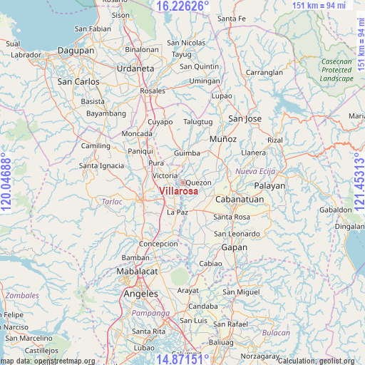
Villarosa GPS coordinates[2]
15° 33' 0" North, 120° 45' 0" East
| Map corner | latitude | longitude |
|---|---|---|
| Upper-left | 16.22626°, | 120.04688° |
| Center: | 15.55°, | 120.75° |
| Lower-right: | 14.87151°, | 121.45313° |
| Map W x H: | 150.6×150.6 km | = 93.6×93.6mi |
| max Lat: | 20.78733° ⇑17.8% North |
| Villarosa: | 15.55° |
| min Lat: | ⇓82.2% South 4.65442° |
| min Long | Villarosa | max Long |
| 117.04868° | 120.75° | 126.58417° |
| W 16.3%⇐ | ⇒83.7% E |
Elevation
Elevation of Villarosa is 23 m = 75 ft, and this is 64.9 m = 213 ft below average elevation for this country.
| Max E: |
2262 m = 7421 ft | 50.3% |
| Avg. | 87.9 m = 288 ft | |
| Villarosa | 23 m = 75 ft | |
Min E: |
-2 m = -7 ft | 49.7% |
See also: Philippines elevation on elevation.city.
Geographical zone
Villarosa is located in North Torrid zone (between Equator and Tropic of Cancer). Distance of this Northern Tropic circle is 876.9 km =544.9 mi to North.| Distance of | km | miles | from Villarosa |
|---|---|---|---|
| North Pole | 8278.1 | 5143.8 | to North |
| Arctic Circle | 5672.2 | 3524.5 | to North |
| Tropic Cancer | 876.9 | 544.9 | to North |
| Equator | 1729 | 1074.4 | to South |


Nearby cities:
15 places around Villarosa: (largest is in red/bold)
• Balayang
6 km =3.7 mi,  269°
269°
• Bundoc
8 km =5 mi,  206°
206°
• Calibungan
6 km =3.7 mi,  332°
332°
• Licab
1.6 km =1 mi,  115°
115°
• Lomboy
7.3 km =4.5 mi, 208°
• Manacsac
6.7 km =4.2 mi,  41°
41°
• Matayumtayum
5.7 km =3.5 mi,  229°
229°
• Nagpandayan
6.1 km =3.8 mi,  19°
19°
• Quezon
6.9 km =4.3 mi,  88°
88°
• San Casimiro
3.3 km =2.1 mi,  84°
84°
• San Cristobal
1.9 km =1.2 mi, 76°
• San Jacinto
8.6 km =5.3 mi, 266°
• Santa Lucia
8 km =5 mi,  160°
160°
• Santa Maria
5.4 km =3.4 mi, 123°
• Victoria
7.9 km =4.9 mi,  292°
292°
Sources, notices
• [Note1] Compared only with cities in Philippines existing in our database
• [Src1] Map data: © OpenStreetMap contributors (CC-BY-SA)
• [Src2] Other city data from geonames.org with taken over terms of usage.
• [Src3] Geographical zone / Annual Mean Temperature by Robert A. Rohde @ Wikipedia
