Nagpandayan geodata
Nagpandayan (Central Luzon) is a populated place; located in Philippines in Asia/Manila (GMT+8) time zone. With population of 3,140 people, there are 2371 cities with bigger population in this country. Compared to other cities in Philippines, 82.9% of cities are located further ↓South; 83.2% of cities are located further →East and 58.1% of cities have lower elevation than Nagpandayan. Note1


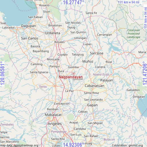
Nagpandayan GPS coordinates[2]
15° 36' 4.968" North, 120° 46' 8.148" East
| Map corner | latitude | longitude |
|---|---|---|
| Upper-left | 16.27747°, | 120.06581° |
| Center: | 15.60138°, | 120.76893° |
| Lower-right: | 14.92306°, | 121.47206° |
| Map W x H: | 150.6×150.6 km | = 93.6×93.6mi |
| max Lat: | 20.78733° ⇑17.1% North |
| Nagpandayan: | 15.60138° |
| min Lat: | ⇓82.9% South 4.65442° |
| min Long | Nagpandayan | max Long |
| 117.04868° | 120.76893° | 126.58417° |
| W 16.8%⇐ | ⇒83.2% E |
Elevation
Elevation of Nagpandayan is 31 m = 102 ft, and this is 56.9 m = 187 ft below average elevation for this country.
| Max E: |
2262 m = 7421 ft | 41.9% |
| Avg. | 87.9 m = 288 ft | |
| Nagpandayan | 31 m = 102 ft | |
Min E: |
-2 m = -7 ft | 58.1% |
See also: Philippines elevation on elevation.city.
Geographical zone
Nagpandayan is located in North Torrid zone (between Equator and Tropic of Cancer). Distance of this Northern Tropic circle is 871.2 km =541.3 mi to North.| Distance of | km | miles | from Nagpandayan |
|---|---|---|---|
| North Pole | 8272.4 | 5140.2 | to North |
| Arctic Circle | 5666.5 | 3521 | to North |
| Tropic Cancer | 871.2 | 541.3 | to North |
| Equator | 1734.7 | 1077.9 | to South |


Nearby cities:
15 places around Nagpandayan: (largest is in red/bold)
• Balayang
9.9 km =6.2 mi,  234°
234°
• Calibungan
4.8 km =3 mi,  265°
265°
• Cavite
8.5 km =5.3 mi,  0°
0°
• Cawayan Bugtong
3.7 km =2.3 mi,  13°
13°
• Guimba
6.6 km =4.1 mi,  359°
359°
• Licab
6.4 km =4 mi,  185°
185°
• Manacsac
2.5 km =1.6 mi,  106°
106°
• Maturanoc
6.7 km =4.2 mi,  21°
21°
• Quezon
7.4 km =4.6 mi,  138°
138°
• San Alejandro
9.7 km =6 mi,  117°
117°
• San Casimiro
5.5 km =3.4 mi,  166°
166°
• San Cristobal
5.3 km =3.3 mi,  182°
182°
• Santa Maria
9.1 km =5.7 mi,  163°
163°
• Victoria
9.7 km =6 mi,  254°
254°
• Villarosa
6.1 km =3.8 mi,  199°
199°
Sources, notices
• [Note1] Compared only with cities in Philippines existing in our database
• [Src1] Map data: © OpenStreetMap contributors (CC-BY-SA)
• [Src2] Other city data from geonames.org with taken over terms of usage.
• [Src3] Geographical zone / Annual Mean Temperature by Robert A. Rohde @ Wikipedia
