San Antonio geodata
San Antonio (Central Luzon) is a seat of a third-order administrative division; located in Philippines in Asia/Manila (GMT+8) time zone. With population of 34,217 people, there are 248 cities with bigger population in this country. Compared to other cities in Philippines, 76.9% of cities are located further ↓South; 96.6% of cities are located further →East and 60.8% of cities have higher elevation than San Antonio. Note1
Administrative division(s):
- Level 1: Central Luzon
- Level 2: Province of Zambales
- Level 3: San Antonio


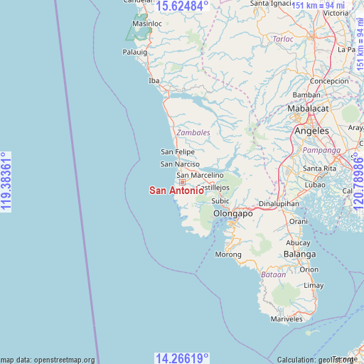
San Antonio GPS coordinates[2]
14° 56' 47.724" North, 120° 5' 12.228" East
| Map corner | latitude | longitude |
|---|---|---|
| Upper-left | 15.62484°, | 119.38361° |
| Center: | 14.94659°, | 120.08673° |
| Lower-right: | 14.26619°, | 120.78986° |
| Map W x H: | 151.1×151.1 km | = 93.9×93.9mi |
| max Lat: | 20.78733° ⇑23.1% North |
| San Antonio: | 14.94659° |
| min Lat: | ⇓76.9% South 4.65442° |
| min Long | San Antonio | max Long |
| 117.04868° | 120.08673° | 126.58417° |
| W 3.4%⇐ | ⇒96.6% E |
Elevation
Elevation of San Antonio is 16 m = 52 ft, and this is 71.9 m = 236 ft below average elevation for this country.
| Max E: |
2262 m = 7421 ft | 60.8% |
| Avg. | 87.9 m = 288 ft | |
| San Antonio | 16 m = 52 ft | |
Min E: |
-2 m = -7 ft | 39.2% |
See also: Philippines elevation on elevation.city.
Geographical zone
San Antonio is located in North Torrid zone (between Equator and Tropic of Cancer). Distance of this Northern Tropic circle is 944 km =586.6 mi to North.| Distance of | km | miles | from San Antonio |
|---|---|---|---|
| North Pole | 8345.2 | 5185.5 | to North |
| Arctic Circle | 5739.3 | 3566.2 | to North |
| Tropic Cancer | 944 | 586.6 | to North |
| Equator | 1661.9 | 1032.7 | to South |


Nearby cities:
15 places around San Antonio: (largest is in red/bold)
• Beddeng
3.4 km =2.1 mi,  356°
356°
• Cabangan
23.7 km =14.7 mi,  352°
352°
• Castillejos
12 km =7.5 mi,  96°
96°
• Maloma
18.7 km =11.6 mi, 352°
• Olongapo
24.8 km =15.4 mi,  121°
121°
• Pamatawan
13.8 km =8.6 mi, 98°
• Panan
30.3 km =18.8 mi, 347°
• Poblacion, San Felipe
13 km =8.1 mi, 352°
• San Agustin
7 km =4.3 mi, 102°
• San Marcelino
8.2 km =5.1 mi,  67°
67°
• San Narciso
7.6 km =4.7 mi, 354°
• San Nicolas
1.1 km =0.7 mi,  284°
284°
• Santa Fe
15 km =9.3 mi,  61°
61°
• Subic
17.3 km =10.7 mi, 115°
• Subic Bay Freeport Zone
27.2 km =16.9 mi,  130°
130°
Sources, notices
• [Note1] Compared only with cities in Philippines existing in our database
• [Src1] Map data: © OpenStreetMap contributors (CC-BY-SA)
• [Src2] Other city data from geonames.org with taken over terms of usage.
• [Src3] Geographical zone / Annual Mean Temperature by Robert A. Rohde @ Wikipedia
