Santa Fe geodata
Santa Fe (Central Luzon) is a populated place; located in Philippines in Asia/Manila (GMT+8) time zone. With population of 2,231 people, there are 3821 cities with bigger population in this country. Compared to other cities in Philippines, 77.6% of cities are located further ↓South; 96% of cities are located further →East and 78% of cities have lower elevation than Santa Fe. Note1
Administrative division(s):
- Level 1: Central Luzon
- Level 2: Province of Zambales
- Level 3: San Marcelino


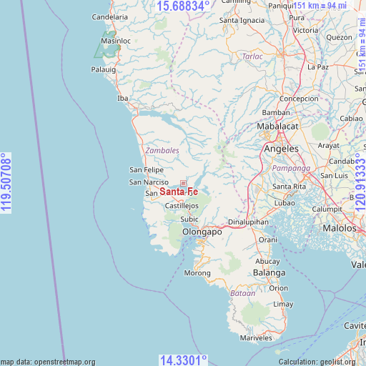
Santa Fe GPS coordinates[2]
15° 0' 37.08" North, 120° 12' 36.72" East
| Map corner | latitude | longitude |
|---|---|---|
| Upper-left | 15.68834°, | 119.50708° |
| Center: | 15.0103°, | 120.2102° |
| Lower-right: | 14.3301°, | 120.91333° |
| Map W x H: | 151×151 km | = 93.8×93.8mi |
| max Lat: | 20.78733° ⇑22.4% North |
| Santa Fe: | 15.0103° |
| min Lat: | ⇓77.6% South 4.65442° |
| min Long | Santa Fe | max Long |
| 117.04868° | 120.2102° | 126.58417° |
| W 4%⇐ | ⇒96% E |
Elevation
Elevation of Santa Fe is 80 m = 262 ft, and this is 7.9 m = 26 ft below average elevation for this country.
| Max E: |
2262 m = 7421 ft | 22% |
| Avg. | 87.9 m = 288 ft | |
| Santa Fe | 80 m = 262 ft | |
Min E: |
-2 m = -7 ft | 78% |
See also: Philippines elevation on elevation.city.
Geographical zone
Santa Fe is located in North Torrid zone (between Equator and Tropic of Cancer). Distance of this Northern Tropic circle is 936.9 km =582.2 mi to North.| Distance of | km | miles | from Santa Fe |
|---|---|---|---|
| North Pole | 8338.1 | 5181.1 | to North |
| Arctic Circle | 5732.2 | 3561.8 | to North |
| Tropic Cancer | 936.9 | 582.2 | to North |
| Equator | 1669 | 1037.1 | to South |


Nearby cities:
15 places around Santa Fe: (largest is in red/bold)
• Beddeng
13.9 km =8.6 mi,  254°
254°
• Cabangan
23.3 km =14.5 mi,  314°
314°
• Castillejos
8.6 km =5.3 mi,  188°
188°
• Maloma
19.5 km =12.1 mi, 306°
• Olongapo
21.6 km =13.4 mi,  158°
158°
• Pamatawan
9.2 km =5.7 mi,  177°
177°
• Poblacion, San Felipe
16.1 km =10 mi,  290°
290°
• San Agustin
10.7 km =6.6 mi,  217°
217°
• San Antonio
15 km =9.3 mi,  241°
241°
• San Benito
29.2 km =18.1 mi,  127°
127°
• San Marcelino
7 km =4.3 mi,  234°
234°
• San Narciso
14 km =8.7 mi,  271°
271°
• San Nicolas
15.8 km =9.8 mi, 244°
• Subic
14.8 km =9.2 mi,  170°
170°
• Subic Bay Freeport Zone
25.7 km =16 mi, 163°
Sources, notices
• [Note1] Compared only with cities in Philippines existing in our database
• [Src1] Map data: © OpenStreetMap contributors (CC-BY-SA)
• [Src2] Other city data from geonames.org with taken over terms of usage.
• [Src3] Geographical zone / Annual Mean Temperature by Robert A. Rohde @ Wikipedia
