Malitubog geodata
Malitubog (Soccsksargen) is a populated place; located in Philippines in Asia/Manila (GMT+8) time zone. With population of 2,241 people, there are 3802 cities with bigger population in this country. Compared to other cities in Philippines, 88.4% of cities are located further ↑North; 81.5% of cities are located further ←West and 78.3% of cities have lower elevation than Malitubog. Note1


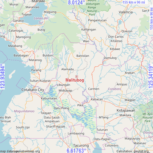
Malitubog GPS coordinates[2]
7° 18' 56.016" North, 124° 38' 17.016" East
| Map corner | latitude | longitude |
|---|---|---|
| Upper-left | 8.0124°, | 123.93494° |
| Center: | 7.31556°, | 124.63806° |
| Lower-right: | 6.61763°, | 125.34119° |
| Map W x H: | 155.1×155.1 km | = 96.4×96.4mi |
| max Lat: | 20.78733° ⇑88.4% North |
| Malitubog: | 7.31556° |
| min Lat: | ⇓11.6% South 4.65442° |
| min Long | Malitubog | max Long |
| 117.04868° | 124.63806° | 126.58417° |
| W 81.5%⇐ | ⇒18.5% E |
Elevation
Elevation of Malitubog is 81 m = 266 ft, and this is 6.9 m = 23 ft below average elevation for this country.
| Max E: |
2262 m = 7421 ft | 21.7% |
| Avg. | 87.9 m = 288 ft | |
| Malitubog | 81 m = 266 ft | |
Min E: |
-2 m = -7 ft | 78.3% |
See also: Philippines elevation on elevation.city.
Geographical zone
Malitubog is located in North Torrid zone (between Equator and Tropic of Cancer). Distance of Equator is 813.4 km =505.4 mi to South.| Distance of | km | miles | from Malitubog |
|---|---|---|---|
| North Pole | 9193.6 | 5712.6 | to North |
| Arctic Circle | 6587.8 | 4093.5 | to North |
| Tropic Cancer | 1792.5 | 1113.8 | to North |
| Equator | 813.4 | 505.4 | to South |


Nearby cities:
15 places around Malitubog: (largest is in red/bold)
• Alamada
8.1 km =5 mi,  284°
284°
• Baguer
16.2 km =10.1 mi,  245°
245°
• Balogo
19.6 km =12.2 mi,  259°
259°
• Barongis
10.2 km =6.3 mi,  233°
233°
• Bau
10.1 km =6.3 mi,  7°
7°
• Bual
20.8 km =12.9 mi,  224°
224°
• Buayan
13.4 km =8.3 mi,  243°
243°
• Dualing
19.8 km =12.3 mi,  202°
202°
• Gocoton
18.7 km =11.6 mi,  161°
161°
• Libungan
15.4 km =9.6 mi, 237°
• Liliongan
17.9 km =11.1 mi,  72°
72°
• Midsayap
18.3 km =11.4 mi, 220°
• Patindeguen
18.7 km =11.6 mi, 235°
• Tomado
14.1 km =8.8 mi,  193°
193°
• Upper San Mateo
17 km =10.6 mi, 201°
Sources, notices
• [Note1] Compared only with cities in Philippines existing in our database
• [Src1] Map data: © OpenStreetMap contributors (CC-BY-SA)
• [Src2] Other city data from geonames.org with taken over terms of usage.
• [Src3] Geographical zone / Annual Mean Temperature by Robert A. Rohde @ Wikipedia
