Liliongan geodata
Liliongan (Soccsksargen) is a populated place; located in Philippines in Asia/Manila (GMT+8) time zone. With population of 3,049 people, there are 2475 cities with bigger population in this country. Compared to other cities in Philippines, 88% of cities are located further ↑North; 84.3% of cities are located further ←West and 87.1% of cities have lower elevation than Liliongan. Note1


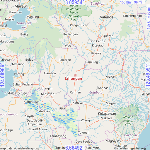
Liliongan GPS coordinates[2]
7° 21' 46.008" North, 124° 47' 34.008" East
| Map corner | latitude | longitude |
|---|---|---|
| Upper-left | 8.05954°, | 124.08966° |
| Center: | 7.36278°, | 124.79278° |
| Lower-right: | 6.66492°, | 125.49591° |
| Map W x H: | 155.1×155.1 km | = 96.4×96.4mi |
| max Lat: | 20.78733° ⇑88% North |
| Liliongan: | 7.36278° |
| min Lat: | ⇓12% South 4.65442° |
| min Long | Liliongan | max Long |
| 117.04868° | 124.79278° | 126.58417° |
| W 84.3%⇐ | ⇒15.7% E |
Elevation
Elevation of Liliongan is 167 m = 548 ft, and this is 79.1 m = 260 ft above average elevation for this country.
| Max E: |
2262 m = 7421 ft | 12.9% |
| Liliongan | 167 m 548 ft | |
| Avg. | 87.9 m = 288 ft | |
Min E: |
-2 m = -7 ft | 87.1% |
See also: Philippines elevation on elevation.city.
Geographical zone
Liliongan is located in North Torrid zone (between Equator and Tropic of Cancer). Distance of Equator is 818.7 km =508.7 mi to South.| Distance of | km | miles | from Liliongan |
|---|---|---|---|
| North Pole | 9188.4 | 5709.4 | to North |
| Arctic Circle | 6582.5 | 4090.2 | to North |
| Tropic Cancer | 1787.3 | 1110.6 | to North |
| Equator | 818.7 | 508.7 | to South |


Nearby cities:
15 places around Liliongan: (largest is in red/bold)
• Alamada
25.1 km =15.6 mi,  262°
262°
• Banawa
24.6 km =15.3 mi,  160°
160°
• Banisilan
16.1 km =10 mi,  332°
332°
• Bau
16.5 km =10.3 mi,  286°
286°
• Bulit
27.5 km =17.1 mi,  180°
180°
• Carmen
17.6 km =10.9 mi, 180°
• Damulog
21.3 km =13.2 mi,  50°
50°
• Gocoton
25.6 km =15.9 mi,  206°
206°
• Limbalod
25.6 km =15.9 mi, 178°
• Malapag
25.6 km =15.9 mi,  174°
174°
• Malinao
23.9 km =14.9 mi,  337°
337°
• Malitubog
17.9 km =11.1 mi,  252°
252°
• Osias
26.5 km =16.5 mi,  5°
5°
• Pedtad
22.6 km =14 mi, 173°
• Sampagar
24.6 km =15.3 mi, 46°
Sources, notices
• [Note1] Compared only with cities in Philippines existing in our database
• [Src1] Map data: © OpenStreetMap contributors (CC-BY-SA)
• [Src2] Other city data from geonames.org with taken over terms of usage.
• [Src3] Geographical zone / Annual Mean Temperature by Robert A. Rohde @ Wikipedia
