Malbug geodata
Malbug (Bicol) is a populated place; located in Philippines in Asia/Manila (GMT+8) time zone. With population of 2,292 people, there are 3702 cities with bigger population in this country. Compared to other cities in Philippines, 52% of cities are located further ↓South; 64.7% of cities are located further ←West and 89.7% of cities have higher elevation than Malbug. Note1


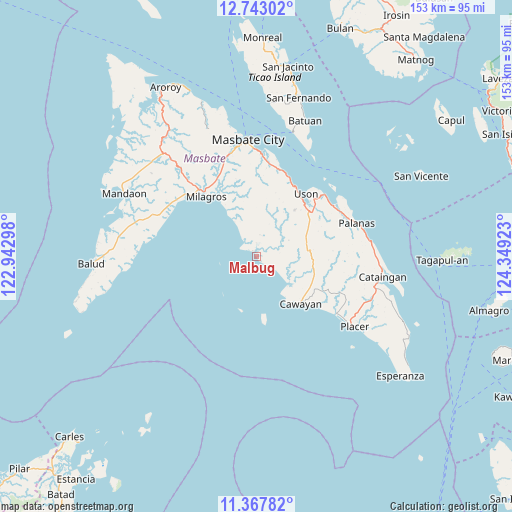
Malbug GPS coordinates[2]
12° 3' 22.68" North, 123° 38' 45.96" East
| Map corner | latitude | longitude |
|---|---|---|
| Upper-left | 12.74302°, | 122.94298° |
| Center: | 12.0563°, | 123.6461° |
| Lower-right: | 11.36782°, | 124.34923° |
| Map W x H: | 152.9×152.9 km | = 95×95mi |
| max Lat: | 20.78733° ⇑48% North |
| Malbug: | 12.0563° |
| min Lat: | ⇓52% South 4.65442° |
| min Long | Malbug | max Long |
| 117.04868° | 123.6461° | 126.58417° |
| W 64.7%⇐ | ⇒35.3% E |
Elevation
Elevation of Malbug is 7 m = 23 ft, and this is 80.9 m = 265 ft below average elevation for this country.
| Max E: |
2262 m = 7421 ft | 89.7% |
| Avg. | 87.9 m = 288 ft | |
| Malbug | 7 m = 23 ft | |
Min E: |
-2 m = -7 ft | 10.3% |
See also: Philippines elevation on elevation.city.
Geographical zone
Malbug is located in North Torrid zone (between Equator and Tropic of Cancer). Distance of this Northern Tropic circle is 1265.4 km =786.3 mi to North.| Distance of | km | miles | from Malbug |
|---|---|---|---|
| North Pole | 8666.5 | 5385.1 | to North |
| Arctic Circle | 6060.6 | 3765.9 | to North |
| Tropic Cancer | 1265.4 | 786.3 | to North |
| Equator | 1340.5 | 832.9 | to South |


Nearby cities:
15 places around Malbug: (largest is in red/bold)
• Armenia
24.3 km =15.1 mi,  25°
25°
• Bacolod
24.3 km =15.1 mi,  322°
322°
• Balucawi
26.8 km =16.7 mi,  52°
52°
• Barra
1.9 km =1.2 mi,  337°
337°
• Buenavista
20.6 km =12.8 mi, 49°
• Calachuchi
21.9 km =13.6 mi,  325°
325°
• Dapdap
22 km =13.7 mi,  36°
36°
• Hamoraon
21.5 km =13.4 mi, 331°
• Magsalangi
16.5 km =10.3 mi, 328°
• Marintoc
26.8 km =16.7 mi,  18°
18°
• Milagros
23.3 km =14.5 mi, 320°
• Naro
18 km =11.2 mi,  170°
170°
• Recodo
15.5 km =9.6 mi,  140°
140°
• Tigbaw
11.9 km =7.4 mi, 329°
• Uson
24 km =14.9 mi, 38°
Sources, notices
• [Note1] Compared only with cities in Philippines existing in our database
• [Src1] Map data: © OpenStreetMap contributors (CC-BY-SA)
• [Src2] Other city data from geonames.org with taken over terms of usage.
• [Src3] Geographical zone / Annual Mean Temperature by Robert A. Rohde @ Wikipedia
