Buenavista geodata
Buenavista (Bicol) is a populated place; located in Philippines in Asia/Manila (GMT+8) time zone. With population of 3,021 people, there are 2498 cities with bigger population in this country. Compared to other cities in Philippines, 52.6% of cities are located further ↓South; 67.8% of cities are located further ←West and 64.7% of cities have lower elevation than Buenavista. Note1


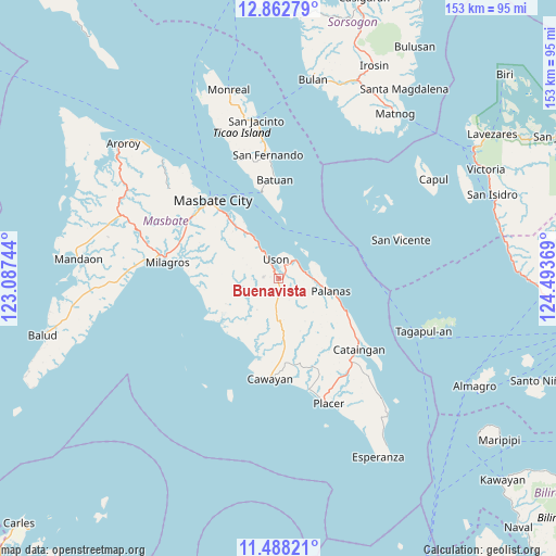
Buenavista GPS coordinates[2]
12° 10' 35.004" North, 123° 47' 26.016" East
| Map corner | latitude | longitude |
|---|---|---|
| Upper-left | 12.86279°, | 123.08744° |
| Center: | 12.17639°, | 123.79056° |
| Lower-right: | 11.48821°, | 124.49369° |
| Map W x H: | 152.8×152.8 km | = 94.9×94.9mi |
| max Lat: | 20.78733° ⇑47.4% North |
| Buenavista: | 12.17639° |
| min Lat: | ⇓52.6% South 4.65442° |
| min Long | Buenavista | max Long |
| 117.04868° | 123.79056° | 126.58417° |
| W 67.8%⇐ | ⇒32.2% E |
Elevation
Elevation of Buenavista is 41 m = 135 ft, and this is 46.9 m = 154 ft below average elevation for this country.
| Max E: |
2262 m = 7421 ft | 35.3% |
| Avg. | 87.9 m = 288 ft | |
| Buenavista | 41 m = 135 ft | |
Min E: |
-2 m = -7 ft | 64.7% |
See also: Philippines elevation on elevation.city.
Geographical zone
Buenavista is located in North Torrid zone (between Equator and Tropic of Cancer). Distance of this Northern Tropic circle is 1252 km =778 mi to North.| Distance of | km | miles | from Buenavista |
|---|---|---|---|
| North Pole | 8653.2 | 5376.8 | to North |
| Arctic Circle | 6047.3 | 3757.6 | to North |
| Tropic Cancer | 1252 | 778 | to North |
| Equator | 1353.9 | 841.3 | to South |


Nearby cities:
15 places around Buenavista: (largest is in red/bold)
• Armenia
10 km =6.2 mi,  329°
329°
• Balucawi
6.3 km =3.9 mi,  63°
63°
• Barra
20.1 km =12.5 mi,  234°
234°
• Dapdap
5.1 km =3.2 mi, 328°
• Dimasalang
7.7 km =4.8 mi,  76°
76°
• Malbug
20.6 km =12.8 mi, 229°
• Marintoc
14.2 km =8.8 mi, 328°
• Miaga
7.4 km =4.6 mi,  22°
22°
• Nabangig
19.4 km =12.1 mi,  116°
116°
• Palanas
14.6 km =9.1 mi,  103°
103°
• Pawican
22.6 km =14 mi, 120°
• Peña
18.8 km =11.7 mi, 121°
• Tigbaw
21.9 km =13.6 mi,  261°
261°
• Umabay
19.1 km =11.9 mi,  320°
320°
• Uson
5.5 km =3.4 mi,  351°
351°
Sources, notices
• [Note1] Compared only with cities in Philippines existing in our database
• [Src1] Map data: © OpenStreetMap contributors (CC-BY-SA)
• [Src2] Other city data from geonames.org with taken over terms of usage.
• [Src3] Geographical zone / Annual Mean Temperature by Robert A. Rohde @ Wikipedia
