Naro geodata
Naro (Bicol) is a populated place; located in Philippines in Asia/Manila (GMT+8) time zone. With population of 2,977 people, there are 2557 cities with bigger population in this country. Compared to other cities in Philippines, 51.3% of cities are located further ↓South; 65.1% of cities are located further ←West and 95.5% of cities have higher elevation than Naro. Note1


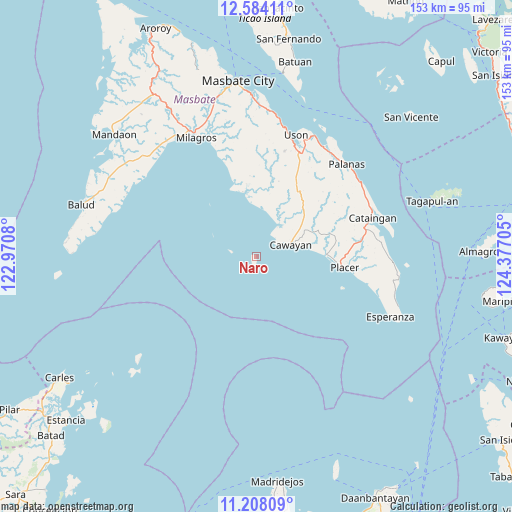
Naro GPS coordinates[2]
11° 53' 49.092" North, 123° 40' 26.112" East
| Map corner | latitude | longitude |
|---|---|---|
| Upper-left | 12.58411°, | 122.9708° |
| Center: | 11.89697°, | 123.67392° |
| Lower-right: | 11.20809°, | 124.37705° |
| Map W x H: | 153×153 km | = 95.1×95.1mi |
| max Lat: | 20.78733° ⇑48.7% North |
| Naro: | 11.89697° |
| min Lat: | ⇓51.3% South 4.65442° |
| min Long | Naro | max Long |
| 117.04868° | 123.67392° | 126.58417° |
| W 65.1%⇐ | ⇒34.9% E |
Elevation
Elevation of Naro is 5 m = 16 ft, and this is 82.9 m = 272 ft below average elevation for this country.
| Max E: |
2262 m = 7421 ft | 95.5% |
| Avg. | 87.9 m = 288 ft | |
| Naro | 5 m = 16 ft | |
Min E: |
-2 m = -7 ft | 4.5% |
See also: Philippines elevation on elevation.city.
Geographical zone
Naro is located in North Torrid zone (between Equator and Tropic of Cancer). Distance of this Northern Tropic circle is 1283.1 km =797.3 mi to North.| Distance of | km | miles | from Naro |
|---|---|---|---|
| North Pole | 8684.2 | 5396.1 | to North |
| Arctic Circle | 6078.4 | 3776.9 | to North |
| Tropic Cancer | 1283.1 | 797.3 | to North |
| Equator | 1322.8 | 821.9 | to South |


Nearby cities:
15 places around Naro: (largest is in red/bold)
• Balucawi
38.5 km =23.9 mi,  28°
28°
• Barra
19.8 km =12.3 mi,  349°
349°
• Buenavista
33.6 km =20.9 mi,  22°
22°
• Cataingan
36.6 km =22.7 mi,  71°
71°
• Dapdap
36.8 km =22.9 mi, 15°
• Magsalangi
33.9 km =21.1 mi,  339°
339°
• Malbug
18 km =11.2 mi, 350°
• Nabangig
37.5 km =23.3 mi,  53°
53°
• Pawican
37.8 km =23.5 mi,  58°
58°
• Peña
35.8 km =22.2 mi, 53°
• Placer
26.8 km =16.7 mi,  96°
96°
• Recodo
9 km =5.6 mi, 49°
• San Pedro
37.9 km =23.5 mi, 69°
• Tigbaw
29.4 km =18.3 mi, 342°
• Uson
38.4 km =23.9 mi, 18°
Sources, notices
• [Note1] Compared only with cities in Philippines existing in our database
• [Src1] Map data: © OpenStreetMap contributors (CC-BY-SA)
• [Src2] Other city data from geonames.org with taken over terms of usage.
• [Src3] Geographical zone / Annual Mean Temperature by Robert A. Rohde @ Wikipedia
