Malasila geodata
Malasila (Soccsksargen) is a populated place; located in Philippines in Asia/Manila (GMT+8) time zone. With population of 5,864 people, there are 1074 cities with bigger population in this country. Compared to other cities in Philippines, 92.3% of cities are located further ↑North; 89.6% of cities are located further ←West and 93.8% of cities have lower elevation than Malasila. Note1


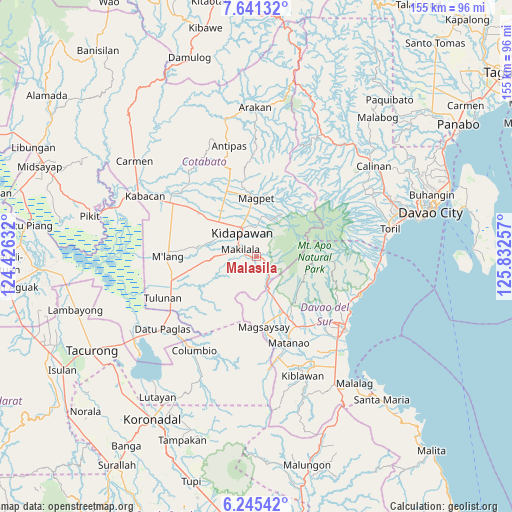
Malasila GPS coordinates[2]
6° 56' 38.004" North, 125° 7' 45.984" East
| Map corner | latitude | longitude |
|---|---|---|
| Upper-left | 7.64132°, | 124.42632° |
| Center: | 6.94389°, | 125.12944° |
| Lower-right: | 6.24542°, | 125.83257° |
| Map W x H: | 155.2×155.2 km | = 96.4×96.4mi |
| max Lat: | 20.78733° ⇑92.3% North |
| Malasila: | 6.94389° |
| min Lat: | ⇓7.7% South 4.65442° |
| min Long | Malasila | max Long |
| 117.04868° | 125.12944° | 126.58417° |
| W 89.6%⇐ | ⇒10.4% E |
Elevation
Elevation of Malasila is 364 m = 1194 ft, and this is 276.1 m = 906 ft above average elevation for this country.
| Max E: |
2262 m = 7421 ft | 6.2% |
| Malasila | 364 m 1194 ft | |
| Avg. | 87.9 m = 288 ft | |
Min E: |
-2 m = -7 ft | 93.8% |
See also: Philippines elevation on elevation.city.
Geographical zone
Malasila is located in North Torrid zone (between Equator and Tropic of Cancer). Distance of Equator is 772.1 km =479.8 mi to South.| Distance of | km | miles | from Malasila |
|---|---|---|---|
| North Pole | 9235 | 5738.4 | to North |
| Arctic Circle | 6629.1 | 4119.1 | to North |
| Tropic Cancer | 1833.8 | 1139.5 | to North |
| Equator | 772.1 | 479.8 | to South |


Nearby cities:
15 places around Malasila: (largest is in red/bold)
• Amas
20.4 km =12.7 mi,  308°
308°
• Bansalan
19.8 km =12.3 mi,  152°
152°
• Batasan
13.3 km =8.3 mi,  318°
318°
• Bulatukan
5.8 km =3.6 mi,  143°
143°
• Dolo
16.4 km =10.2 mi,  155°
155°
• Kalaisan
11.9 km =7.4 mi, 308°
• Kidapawan
8.4 km =5.2 mi,  328°
328°
• Kisante
3.7 km =2.3 mi,  129°
129°
• Labu-o
21.1 km =13.1 mi, 333°
• Magpet
17.4 km =10.8 mi,  354°
354°
• Magsaysay
20.6 km =12.8 mi, 163°
• Makilala
3.7 km =2.3 mi,  283°
283°
• New Cebu
19.9 km =12.4 mi, 327°
• Saguing
7 km =4.3 mi, 305°
• Sinawilan
24.7 km =15.3 mi, 148°
Sources, notices
• [Note1] Compared only with cities in Philippines existing in our database
• [Src1] Map data: © OpenStreetMap contributors (CC-BY-SA)
• [Src2] Other city data from geonames.org with taken over terms of usage.
• [Src3] Geographical zone / Annual Mean Temperature by Robert A. Rohde @ Wikipedia
