Malabago geodata
Malabago (Ilocos) is a populated place; located in Philippines in Asia/Manila (GMT+8) time zone. With population of 3,618 people, there are 1966 cities with bigger population in this country. Compared to other cities in Philippines, 87.2% of cities are located further ↓South; 94.6% of cities are located further →East and 70.2% of cities have higher elevation than Malabago. Note1


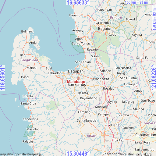
Malabago GPS coordinates[2]
15° 58' 53.544" North, 120° 21' 32.868" East
| Map corner | latitude | longitude |
|---|---|---|
| Upper-left | 16.65633°, | 119.65601° |
| Center: | 15.98154°, | 120.35913° |
| Lower-right: | 15.30446°, | 121.06226° |
| Map W x H: | 150.3×150.3 km | = 93.4×93.4mi |
| max Lat: | 20.78733° ⇑12.8% North |
| Malabago: | 15.98154° |
| min Lat: | ⇓87.2% South 4.65442° |
| min Long | Malabago | max Long |
| 117.04868° | 120.35913° | 126.58417° |
| W 5.4%⇐ | ⇒94.6% E |
Elevation
Elevation of Malabago is 12 m = 39 ft, and this is 75.9 m = 249 ft below average elevation for this country.
| Max E: |
2262 m = 7421 ft | 70.2% |
| Avg. | 87.9 m = 288 ft | |
| Malabago | 12 m = 39 ft | |
Min E: |
-2 m = -7 ft | 29.8% |
See also: Philippines elevation on elevation.city.
Geographical zone
Malabago is located in North Torrid zone (between Equator and Tropic of Cancer). Distance of this Northern Tropic circle is 828.9 km =515.1 mi to North.| Distance of | km | miles | from Malabago |
|---|---|---|---|
| North Pole | 8230.1 | 5113.9 | to North |
| Arctic Circle | 5624.2 | 3494.7 | to North |
| Tropic Cancer | 828.9 | 515.1 | to North |
| Equator | 1777 | 1104.2 | to South |


Nearby cities:
15 places around Malabago: (largest is in red/bold)
• Balingueo
6 km =3.7 mi,  115°
115°
• Bolingit
2.7 km =1.7 mi,  201°
201°
• Bulog
5.1 km =3.2 mi, 117°
• Calasiao
3.3 km =2.1 mi,  1°
1°
• Camaley
6.4 km =4 mi,  285°
285°
• Doyong
1.2 km =0.7 mi,  208°
208°
• Gayaman
6.6 km =4.1 mi,  303°
303°
• Malanay
6.2 km =3.9 mi,  60°
60°
• Nagsaing
2.3 km =1.4 mi,  267°
267°
• Pangpang
7.1 km =4.4 mi,  228°
228°
• Patayac
7.1 km =4.4 mi,  106°
106°
• Quintong
4.9 km =3 mi, 234°
• Santa Barbara
5.1 km =3.2 mi, 64°
• Sonquil
3.4 km =2.1 mi,  77°
77°
• Tandoc
4 km =2.5 mi, 232°
Sources, notices
• [Note1] Compared only with cities in Philippines existing in our database
• [Src1] Map data: © OpenStreetMap contributors (CC-BY-SA)
• [Src2] Other city data from geonames.org with taken over terms of usage.
• [Src3] Geographical zone / Annual Mean Temperature by Robert A. Rohde @ Wikipedia
