Lucban geodata
Lucban (Calabarzon) is a populated place; located in Philippines in Asia/Manila (GMT+8) time zone. With population of 30,992 people, there are 270 cities with bigger population in this country. Compared to other cities in Philippines, 70.6% of cities are located further ↓South; 65.8% of cities are located further →East and 95.2% of cities have lower elevation than Lucban. Note1


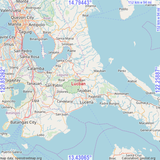
Lucban GPS coordinates[2]
14° 6' 48.816" North, 121° 33' 20.664" East
| Map corner | latitude | longitude |
|---|---|---|
| Upper-left | 14.79443°, | 120.85262° |
| Center: | 14.11356°, | 121.55574° |
| Lower-right: | 13.43065°, | 122.25887° |
| Map W x H: | 151.6×151.6 km | = 94.2×94.2mi |
| max Lat: | 20.78733° ⇑29.4% North |
| Lucban: | 14.11356° |
| min Lat: | ⇓70.6% South 4.65442° |
| min Long | Lucban | max Long |
| 117.04868° | 121.55574° | 126.58417° |
| W 34.2%⇐ | ⇒65.8% E |
Elevation
Elevation of Lucban is 431 m = 1414 ft, and this is 343.1 m = 1126 ft above average elevation for this country.
| Max E: |
2262 m = 7421 ft | 4.8% |
| Lucban | 431 m 1414 ft | |
| Avg. | 87.9 m = 288 ft | |
Min E: |
-2 m = -7 ft | 95.2% |
See also: Philippines elevation on elevation.city.
Geographical zone
Lucban is located in North Torrid zone (between Equator and Tropic of Cancer). Distance of this Northern Tropic circle is 1036.6 km =644.1 mi to North.| Distance of | km | miles | from Lucban |
|---|---|---|---|
| North Pole | 8437.8 | 5243 | to North |
| Arctic Circle | 5831.9 | 3623.8 | to North |
| Tropic Cancer | 1036.6 | 644.1 | to North |
| Equator | 1569.3 | 975.1 | to South |


Nearby cities:
15 places around Lucban: (largest is in red/bold)
• Calumpang
13.8 km =8.6 mi,  182°
182°
• Cavinti
15.5 km =9.6 mi,  340°
340°
• Lilio
13 km =8.1 mi,  278°
278°
• Luisiana
9.3 km =5.8 mi,  328°
328°
• Majayjay
9.6 km =6 mi,  292°
292°
• Mamala
11.6 km =7.2 mi,  201°
201°
• Nagcarlan
15.2 km =9.4 mi, 279°
• Sampaloc
10.6 km =6.6 mi,  58°
58°
• San Antonio
11.3 km =7 mi, 327°
• San Diego
11.1 km =6.9 mi,  317°
317°
• San Rafael
15.3 km =9.5 mi, 276°
• Santa Lucia
16 km =9.9 mi,  236°
236°
• Santo Tomas
9.8 km =6.1 mi, 322°
• Tayabas
10.5 km =6.5 mi,  157°
157°
• Taytay
16.4 km =10.2 mi,  274°
274°
Sources, notices
• [Note1] Compared only with cities in Philippines existing in our database
• [Src1] Map data: © OpenStreetMap contributors (CC-BY-SA)
• [Src2] Other city data from geonames.org with taken over terms of usage.
• [Src3] Geographical zone / Annual Mean Temperature by Robert A. Rohde @ Wikipedia
