Macabebe geodata
Macabebe (Central Luzon) is a seat of a third-order administrative division; located in Philippines in Asia/Manila (GMT+8) time zone. In our database, there are 4166 cities with bigger population. Compared to other cities in Philippines, 76.5% of cities are located further ↓South; 84.6% of cities are located further →East and 85.4% of cities have higher elevation than Macabebe. Note1


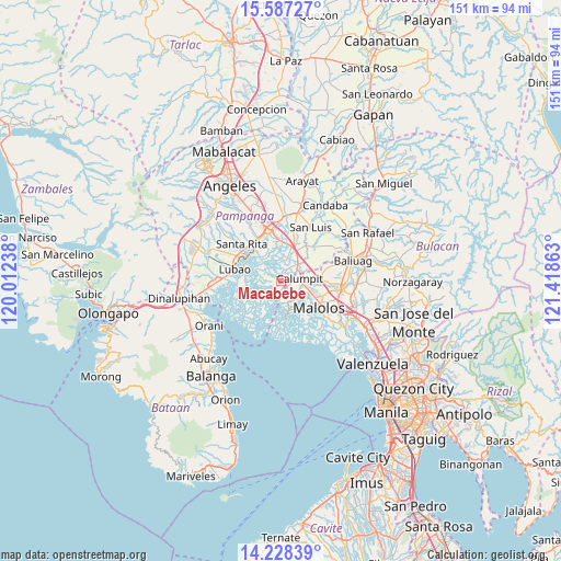
Macabebe GPS coordinates[2]
14° 54' 32.04" North, 120° 42' 55.8" East
| Map corner | latitude | longitude |
|---|---|---|
| Upper-left | 15.58727°, | 120.01238° |
| Center: | 14.9089°, | 120.7155° |
| Lower-right: | 14.22839°, | 121.41863° |
| Map W x H: | 151.1×151.1 km | = 93.9×93.9mi |
| max Lat: | 20.78733° ⇑23.5% North |
| Macabebe: | 14.9089° |
| min Lat: | ⇓76.5% South 4.65442° |
| min Long | Macabebe | max Long |
| 117.04868° | 120.7155° | 126.58417° |
| W 15.4%⇐ | ⇒84.6% E |
Elevation
Elevation of Macabebe is 8 m = 26 ft, and this is 79.9 m = 262 ft below average elevation for this country.
| Max E: |
2262 m = 7421 ft | 85.4% |
| Avg. | 87.9 m = 288 ft | |
| Macabebe | 8 m = 26 ft | |
Min E: |
-2 m = -7 ft | 14.6% |
See also: Philippines elevation on elevation.city.
Geographical zone
Macabebe is located in North Torrid zone (between Equator and Tropic of Cancer). Distance of this Northern Tropic circle is 948.2 km =589.2 mi to North.| Distance of | km | miles | from Macabebe |
|---|---|---|---|
| North Pole | 8349.3 | 5188 | to North |
| Arctic Circle | 5743.5 | 3568.8 | to North |
| Tropic Cancer | 948.2 | 589.2 | to North |
| Equator | 1657.7 | 1030 | to South |


Nearby cities:
15 places around Macabebe: (largest is in red/bold)
• Apalit
7.7 km =4.8 mi,  49°
49°
• Balite
7.9 km =4.9 mi,  101°
101°
• Balucuc
11.7 km =7.3 mi,  65°
65°
• Calumpit
5.5 km =3.4 mi,  81°
81°
• Dampol
11.5 km =7.1 mi,  94°
94°
• Guagua
10.9 km =6.8 mi,  305°
305°
• Hagonoy
8.5 km =5.3 mi,  167°
167°
• Lourdes
7.3 km =4.5 mi,  331°
331°
• Malusac
11.6 km =7.2 mi,  241°
241°
• Masantol
1.6 km =1 mi,  205°
205°
• Minalin
7.4 km =4.6 mi, 331°
• San Rafael
2.6 km =1.6 mi,  245°
245°
• San Vicente
5.4 km =3.4 mi,  40°
40°
• Santo Domingo
9.6 km =6 mi,  18°
18°
• Sexmoan
10.7 km =6.6 mi,  291°
291°
Sources, notices
• [Note1] Compared only with cities in Philippines existing in our database
• [Src1] Map data: © OpenStreetMap contributors (CC-BY-SA)
• [Src2] Other city data from geonames.org with taken over terms of usage.
• [Src3] Geographical zone / Annual Mean Temperature by Robert A. Rohde @ Wikipedia
