Hagonoy geodata
Hagonoy (Central Luzon) is a populated place; located in Philippines in Asia/Manila (GMT+8) time zone. With population of 123,531 people, there are 77 cities with bigger population in this country. Compared to other cities in Philippines, 75.9% of cities are located further ↓South; 84% of cities are located further →East and 92.7% of cities have higher elevation than Hagonoy. Note1


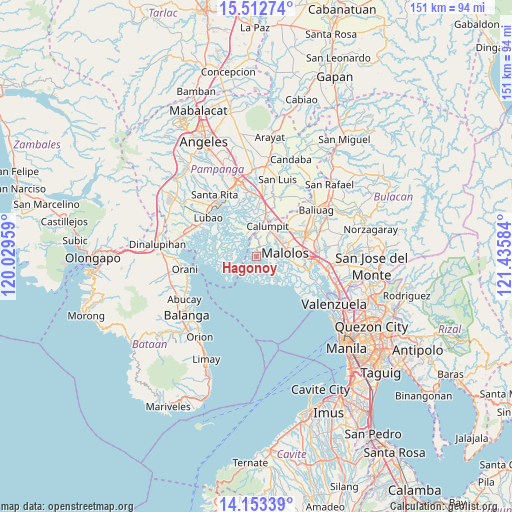
Hagonoy GPS coordinates[2]
14° 50' 2.868" North, 120° 43' 57.756" East
| Map corner | latitude | longitude |
|---|---|---|
| Upper-left | 15.51274°, | 120.02959° |
| Center: | 14.83413°, | 120.73271° |
| Lower-right: | 14.15339°, | 121.43584° |
| Map W x H: | 151.1×151.1 km | = 93.9×93.9mi |
| max Lat: | 20.78733° ⇑24.1% North |
| Hagonoy: | 14.83413° |
| min Lat: | ⇓75.9% South 4.65442° |
| min Long | Hagonoy | max Long |
| 117.04868° | 120.73271° | 126.58417° |
| W 16%⇐ | ⇒84% E |
Elevation
Elevation of Hagonoy is 6 m = 20 ft, and this is 81.9 m = 269 ft below average elevation for this country.
| Max E: |
2262 m = 7421 ft | 92.7% |
| Avg. | 87.9 m = 288 ft | |
| Hagonoy | 6 m = 20 ft | |
Min E: |
-2 m = -7 ft | 7.3% |
See also: Hagonoy elevation on elevation.city.
Geographical zone
Hagonoy is located in North Torrid zone (between Equator and Tropic of Cancer). Distance of this Northern Tropic circle is 956.5 km =594.3 mi to North.| Distance of | km | miles | from Hagonoy |
|---|---|---|---|
| North Pole | 8357.7 | 5193.2 | to North |
| Arctic Circle | 5751.8 | 3574 | to North |
| Tropic Cancer | 956.5 | 594.3 | to North |
| Equator | 1649.4 | 1024.9 | to South |


Nearby cities:
15 places around Hagonoy: (largest is in red/bold)
• Apalit
13.8 km =8.6 mi,  16°
16°
• Balagtas
14.5 km =9 mi,  97°
97°
• Balite
9 km =5.6 mi,  40°
40°
• Calumpit
9.8 km =6.1 mi, 21°
• Dampol
12.1 km =7.5 mi,  52°
52°
• Lourdes
15.7 km =9.8 mi,  340°
340°
• Macabebe
8.5 km =5.3 mi,  347°
347°
• Malolos
8.4 km =5.2 mi,  82°
82°
• Malusac
12.3 km =7.6 mi,  282°
282°
• Masantol
7.3 km =4.5 mi, 339°
• Paombong
6.1 km =3.8 mi,  93°
93°
• Plaridel
14.6 km =9.1 mi,  66°
66°
• Pulilan
14.6 km =9.1 mi,  59°
59°
• San Rafael
8.4 km =5.2 mi,  329°
329°
• San Vicente
12.5 km =7.8 mi,  7°
7°
Sources, notices
• [Note1] Compared only with cities in Philippines existing in our database
• [Src1] Map data: © OpenStreetMap contributors (CC-BY-SA)
• [Src2] Other city data from geonames.org with taken over terms of usage.
• [Src3] Geographical zone / Annual Mean Temperature by Robert A. Rohde @ Wikipedia
