Lourdes geodata
Lourdes (Central Luzon) is a populated place; located in Philippines in Asia/Manila (GMT+8) time zone. With population of 11,155 people, there are 551 cities with bigger population in this country. Compared to other cities in Philippines, 77.2% of cities are located further ↓South; 85.4% of cities are located further →East and 89.7% of cities have higher elevation than Lourdes. Note1


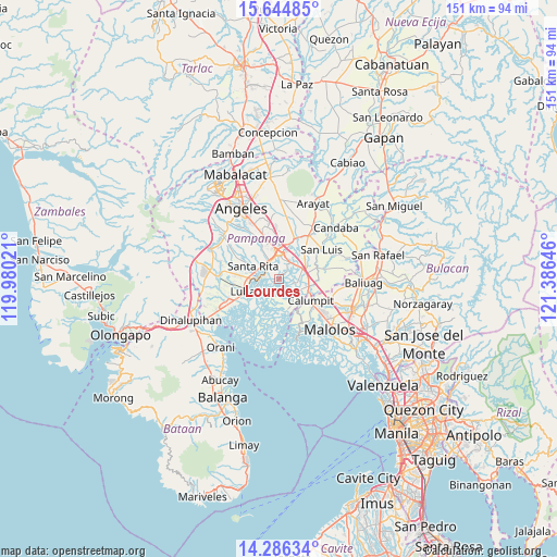
Lourdes GPS coordinates[2]
14° 58' 0.012" North, 120° 40' 59.988" East
| Map corner | latitude | longitude |
|---|---|---|
| Upper-left | 15.64485°, | 119.98021° |
| Center: | 14.96667°, | 120.68333° |
| Lower-right: | 14.28634°, | 121.38646° |
| Map W x H: | 151.1×151.1 km | = 93.9×93.9mi |
| max Lat: | 20.78733° ⇑22.8% North |
| Lourdes: | 14.96667° |
| min Lat: | ⇓77.2% South 4.65442° |
| min Long | Lourdes | max Long |
| 117.04868° | 120.68333° | 126.58417° |
| W 14.6%⇐ | ⇒85.4% E |
Elevation
Elevation of Lourdes is 7 m = 23 ft, and this is 80.9 m = 265 ft below average elevation for this country.
| Max E: |
2262 m = 7421 ft | 89.7% |
| Avg. | 87.9 m = 288 ft | |
| Lourdes | 7 m = 23 ft | |
Min E: |
-2 m = -7 ft | 10.3% |
See also: Philippines elevation on elevation.city.
Geographical zone
Lourdes is located in North Torrid zone (between Equator and Tropic of Cancer). Distance of this Northern Tropic circle is 941.8 km =585.2 mi to North.| Distance of | km | miles | from Lourdes |
|---|---|---|---|
| North Pole | 8342.9 | 5184 | to North |
| Arctic Circle | 5737 | 3564.8 | to North |
| Tropic Cancer | 941.8 | 585.2 | to North |
| Equator | 1664.1 | 1034 | to South |


Nearby cities:
15 places around Lourdes: (largest is in red/bold)
• Bacolor
5 km =3.1 mi,  318°
318°
• Del Pilar
7.9 km =4.9 mi,  12°
12°
• Guagua
5.5 km =3.4 mi,  268°
268°
• Macabebe
7.3 km =4.5 mi,  151°
151°
• Magliman
7.9 km =4.9 mi,  344°
344°
• Masantol
8.3 km =5.2 mi,  160°
160°
• Minalin
0.1 km =0.1 mi,  331°
331°
• Pau
8.1 km =5 mi,  32°
32°
• San Antonio
7.7 km =4.8 mi, 270°
• San Fernando
7.5 km =4.7 mi,  0°
0°
• San Juan
6.3 km =3.9 mi,  353°
353°
• San Rafael
7.6 km =4.7 mi,  171°
171°
• San Vicente
7.4 km =4.6 mi,  108°
108°
• Santo Domingo
7 km =4.3 mi,  67°
67°
• Sexmoan
7 km =4.3 mi,  248°
248°
Sources, notices
• [Note1] Compared only with cities in Philippines existing in our database
• [Src1] Map data: © OpenStreetMap contributors (CC-BY-SA)
• [Src2] Other city data from geonames.org with taken over terms of usage.
• [Src3] Geographical zone / Annual Mean Temperature by Robert A. Rohde @ Wikipedia
