Loyola geodata
Loyola (Caraga) is a populated place; located in Philippines in Asia/Manila (GMT+8) time zone. With population of 2,673 people, there are 2996 cities with bigger population in this country. Compared to other cities in Philippines, 79.8% of cities are located further ↑North; 99.5% of cities are located further ←West and 57.6% of cities have higher elevation than Loyola. Note1


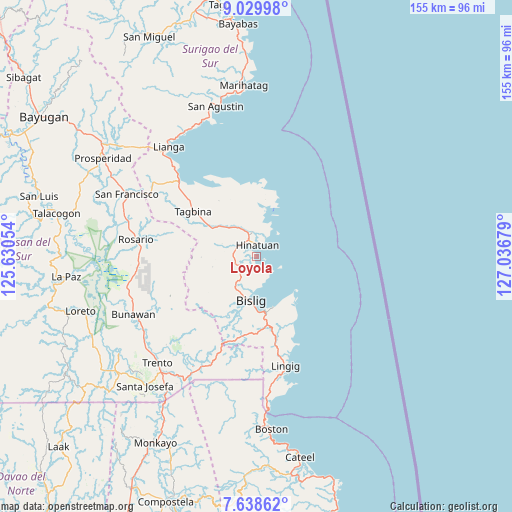
Loyola GPS coordinates[2]
8° 20' 5.712" North, 126° 20' 1.176" East
| Map corner | latitude | longitude |
|---|---|---|
| Upper-left | 9.02998°, | 125.63054° |
| Center: | 8.33492°, | 126.33366° |
| Lower-right: | 7.63862°, | 127.03679° |
| Map W x H: | 154.7×154.7 km | = 96.1×96.1mi |
| max Lat: | 20.78733° ⇑79.8% North |
| Loyola: | 8.33492° |
| min Lat: | ⇓20.2% South 4.65442° |
| min Long | Loyola | max Long |
| 117.04868° | 126.33366° | 126.58417° |
| W 99.5%⇐ | ⇒0.5% E |
Elevation
Elevation of Loyola is 18 m = 59 ft, and this is 69.9 m = 229 ft below average elevation for this country.
| Max E: |
2262 m = 7421 ft | 57.6% |
| Avg. | 87.9 m = 288 ft | |
| Loyola | 18 m = 59 ft | |
Min E: |
-2 m = -7 ft | 42.4% |
See also: Philippines elevation on elevation.city.
Geographical zone
Loyola is located in North Torrid zone (between Equator and Tropic of Cancer). Distance of Equator is 926.8 km =575.9 mi to South.| Distance of | km | miles | from Loyola |
|---|---|---|---|
| North Pole | 9080.3 | 5642.2 | to North |
| Arctic Circle | 6474.4 | 4023 | to North |
| Tropic Cancer | 1679.2 | 1043.4 | to North |
| Equator | 926.8 | 575.9 | to South |


Nearby cities:
15 places around Loyola: (largest is in red/bold)
• Amaga
36.2 km =22.5 mi,  306°
306°
• Barcelona
22.5 km =14 mi,  150°
150°
• Barobo
32.3 km =20.1 mi, 313°
• Bigaan
6.1 km =3.8 mi,  251°
251°
• Bislig
13.4 km =8.3 mi,  188°
188°
• Gamut
24.1 km =15 mi,  335°
335°
• Hinatuan
4.1 km =2.5 mi,  0°
0°
• Javier
32.3 km =20.1 mi,  302°
302°
• Lapinigan
39.8 km =24.7 mi,  283°
283°
• Lingig
34 km =21.1 mi,  165°
165°
• Rosario
36.8 km =22.9 mi, 279°
• Santa Maria
38.5 km =23.9 mi,  209°
209°
• Tagbina
22.1 km =13.7 mi, 306°
• Tidman
4.1 km =2.5 mi, 171°
• Unidad
25.1 km =15.6 mi,  332°
332°
Sources, notices
• [Note1] Compared only with cities in Philippines existing in our database
• [Src1] Map data: © OpenStreetMap contributors (CC-BY-SA)
• [Src2] Other city data from geonames.org with taken over terms of usage.
• [Src3] Geographical zone / Annual Mean Temperature by Robert A. Rohde @ Wikipedia
