Hinatuan geodata
Hinatuan (Caraga) is a seat of a third-order administrative division; located in Philippines in Asia/Manila (GMT+8) time zone. With population of 10,055 people, there are 608 cities with bigger population in this country. Compared to other cities in Philippines, 79.5% of cities are located further ↑North; 99.5% of cities are located further ←West and 89.7% of cities have higher elevation than Hinatuan. Note1


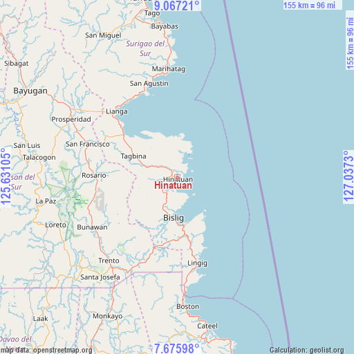
Hinatuan GPS coordinates[2]
8° 22' 19.992" North, 126° 20' 3.012" East
| Map corner | latitude | longitude |
|---|---|---|
| Upper-left | 9.06721°, | 125.63105° |
| Center: | 8.37222°, | 126.33417° |
| Lower-right: | 7.67598°, | 127.0373° |
| Map W x H: | 154.7×154.7 km | = 96.1×96.1mi |
| max Lat: | 20.78733° ⇑79.5% North |
| Hinatuan: | 8.37222° |
| min Lat: | ⇓20.5% South 4.65442° |
| min Long | Hinatuan | max Long |
| 117.04868° | 126.33417° | 126.58417° |
| W 99.5%⇐ | ⇒0.5% E |
Elevation
Elevation of Hinatuan is 7 m = 23 ft, and this is 80.9 m = 265 ft below average elevation for this country.
| Max E: |
2262 m = 7421 ft | 89.7% |
| Avg. | 87.9 m = 288 ft | |
| Hinatuan | 7 m = 23 ft | |
Min E: |
-2 m = -7 ft | 10.3% |
See also: Philippines elevation on elevation.city.
Geographical zone
Hinatuan is located in North Torrid zone (between Equator and Tropic of Cancer). Distance of Equator is 930.9 km =578.4 mi to South.| Distance of | km | miles | from Hinatuan |
|---|---|---|---|
| North Pole | 9076.2 | 5639.7 | to North |
| Arctic Circle | 6470.3 | 4020.5 | to North |
| Tropic Cancer | 1675 | 1040.8 | to North |
| Equator | 930.9 | 578.4 | to South |


Nearby cities:
15 places around Hinatuan: (largest is in red/bold)
• Alegria
38.5 km =23.9 mi,  292°
292°
• Amaga
34 km =21.1 mi,  301°
301°
• Barcelona
26.1 km =16.2 mi,  155°
155°
• Barobo
29.6 km =18.4 mi,  307°
307°
• Bigaan
8.5 km =5.3 mi,  223°
223°
• Bislig
17.6 km =10.9 mi,  186°
186°
• Gamut
20.5 km =12.7 mi,  329°
329°
• Javier
30.3 km =18.8 mi, 295°
• Lapinigan
39.1 km =24.3 mi,  277°
277°
• Lingig
38.1 km =23.7 mi,  166°
166°
• Loyola
4.1 km =2.5 mi,  180°
180°
• Rosario
36.4 km =22.6 mi,  272°
272°
• Tagbina
20 km =12.4 mi, 296°
• Tidman
8.2 km =5.1 mi, 176°
• Unidad
21.6 km =13.4 mi, 327°
Sources, notices
• [Note1] Compared only with cities in Philippines existing in our database
• [Src1] Map data: © OpenStreetMap contributors (CC-BY-SA)
• [Src2] Other city data from geonames.org with taken over terms of usage.
• [Src3] Geographical zone / Annual Mean Temperature by Robert A. Rohde @ Wikipedia
