Magallanes geodata
Magallanes (Calabarzon) is a seat of a third-order administrative division; located in Philippines in Asia/Manila (GMT+8) time zone. With population of 3,396 people, there are 2136 cities with bigger population in this country. Compared to other cities in Philippines, 71.7% of cities are located further ↓South; 83.5% of cities are located further →East and 87.2% of cities have lower elevation than Magallanes. Note1


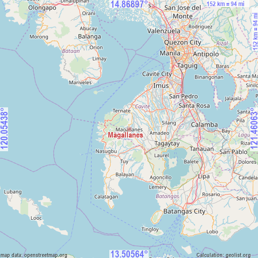
Magallanes GPS coordinates[2]
14° 11' 17.988" North, 120° 45' 27" East
| Map corner | latitude | longitude |
|---|---|---|
| Upper-left | 14.86897°, | 120.05438° |
| Center: | 14.18833°, | 120.7575° |
| Lower-right: | 13.50564°, | 121.46063° |
| Map W x H: | 151.6×151.6 km | = 94.2×94.2mi |
| max Lat: | 20.78733° ⇑28.3% North |
| Magallanes: | 14.18833° |
| min Lat: | ⇓71.7% South 4.65442° |
| min Long | Magallanes | max Long |
| 117.04868° | 120.7575° | 126.58417° |
| W 16.5%⇐ | ⇒83.5% E |
Elevation
Elevation of Magallanes is 169 m = 554 ft, and this is 81.1 m = 266 ft above average elevation for this country.
| Max E: |
2262 m = 7421 ft | 12.8% |
| Magallanes | 169 m 554 ft | |
| Avg. | 87.9 m = 288 ft | |
Min E: |
-2 m = -7 ft | 87.2% |
See also: Philippines elevation on elevation.city.
Geographical zone
Magallanes is located in North Torrid zone (between Equator and Tropic of Cancer). Distance of this Northern Tropic circle is 1028.3 km =639 mi to North.| Distance of | km | miles | from Magallanes |
|---|---|---|---|
| North Pole | 8429.5 | 5237.8 | to North |
| Arctic Circle | 5823.6 | 3618.6 | to North |
| Tropic Cancer | 1028.3 | 639 | to North |
| Equator | 1577.6 | 980.3 | to South |


Nearby cities:
15 places around Magallanes: (largest is in red/bold)
• Aga
11.3 km =7 mi,  154°
154°
• Alfonso
11.7 km =7.3 mi,  116°
116°
• Banaba
10.5 km =6.5 mi,  72°
72°
• Batas
6.5 km =4 mi,  78°
78°
• General Emilio Aguinaldo
4.2 km =2.6 mi,  96°
96°
• Guyam Malaki
11.9 km =7.4 mi,  109°
109°
• Kaytitinga
11.9 km =7.4 mi,  139°
139°
• Malainen Luma
9.7 km =6 mi,  20°
20°
• Maragondon
9.7 km =6 mi,  347°
347°
• Matagbak
10.5 km =6.5 mi,  127°
127°
• Palangue
12.1 km =7.5 mi,  28°
28°
• Pantijan No 2
6.8 km =4.2 mi,  43°
43°
• Taywanak Ilaya
10.2 km =6.3 mi, 109°
• Ternate
12.1 km =7.5 mi,  338°
338°
• Tulay
9.1 km =5.7 mi,  7°
7°
Sources, notices
• [Note1] Compared only with cities in Philippines existing in our database
• [Src1] Map data: © OpenStreetMap contributors (CC-BY-SA)
• [Src2] Other city data from geonames.org with taken over terms of usage.
• [Src3] Geographical zone / Annual Mean Temperature by Robert A. Rohde @ Wikipedia
