El Nido geodata
El Nido (Mimaropa) is a seat of a third-order administrative division; located in Philippines in Asia/Manila (GMT+8) time zone. With population of 7,801 people, there are 795 cities with bigger population in this country. Compared to other cities in Philippines, 54.7% of cities are located further ↑North; 98.9% of cities are located further →East and 61.5% of cities have lower elevation than El Nido. Note1
Administrative division(s):
- Level 1: Mimaropa
- Level 2: Province of Palawan
- Level 3: El Nido (Bacuit)


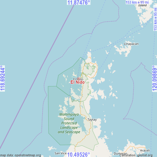
El Nido GPS coordinates[2]
11° 11' 8.988" North, 119° 23' 44.016" East
| Map corner | latitude | longitude |
|---|---|---|
| Upper-left | 11.87476°, | 118.69244° |
| Center: | 11.18583°, | 119.39556° |
| Lower-right: | 10.49526°, | 120.09869° |
| Map W x H: | 153.4×153.4 km | = 95.3×95.3mi |
| max Lat: | 20.78733° ⇑54.7% North |
| El Nido: | 11.18583° |
| min Lat: | ⇓45.3% South 4.65442° |
| min Long | El Nido | max Long |
| 117.04868° | 119.39556° | 126.58417° |
| W 1.1%⇐ | ⇒98.9% E |
Elevation
Elevation of El Nido is 36 m = 118 ft, and this is 51.9 m = 170 ft below average elevation for this country.
| Max E: |
2262 m = 7421 ft | 38.5% |
| Avg. | 87.9 m = 288 ft | |
| El Nido | 36 m = 118 ft | |
Min E: |
-2 m = -7 ft | 61.5% |
See also: Philippines elevation on elevation.city.
Geographical zone
El Nido is located in North Torrid zone (between Equator and Tropic of Cancer). Distance of Equator is 1243.7 km =772.8 mi to South.| Distance of | km | miles | from El Nido |
|---|---|---|---|
| North Pole | 8763.3 | 5445.3 | to North |
| Arctic Circle | 6157.4 | 3826 | to North |
| Tropic Cancer | 1362.2 | 846.4 | to North |
| Equator | 1243.7 | 772.8 | to South |


Nearby cities:
15 places around El Nido: (largest is in red/bold)
• Alemanguan
64.3 km =40 mi,  186°
186°
• Bato
41 km =25.5 mi,  168°
168°
• Calauag
60.6 km =37.7 mi,  161°
161°
• Casian
38.5 km =23.9 mi,  115°
115°
• Dumaran
83.9 km =52.1 mi,  151°
151°
• Guinlo
43.1 km =26.8 mi, 173°
• Limanancong
22.2 km =13.8 mi, 190°
• New Agutaya
70.1 km =43.6 mi, 187°
• Pancol
35 km =21.7 mi,  176°
176°
• Port Barton
80.6 km =50.1 mi, 191°
• San Miguel
62 km =38.5 mi,  56°
56°
• San Vicente
74.5 km =46.3 mi, 191°
• Taytay
42.4 km =26.3 mi, 164°
• Tiniguiban
22.5 km =14 mi,  32°
32°
• Tumarbong
90.2 km =56 mi, 175°
Sources, notices
• [Note1] Compared only with cities in Philippines existing in our database
• [Src1] Map data: © OpenStreetMap contributors (CC-BY-SA)
• [Src2] Other city data from geonames.org with taken over terms of usage.
• [Src3] Geographical zone / Annual Mean Temperature by Robert A. Rohde @ Wikipedia
