Laya geodata
Laya (Cordillera) is a populated place; located in Philippines in Asia/Manila (GMT+8) time zone. With population of 3,787 people, there are 1853 cities with bigger population in this country. Compared to other cities in Philippines, 96% of cities are located further ↓South; 67.1% of cities are located further →East and 85.3% of cities have lower elevation than Laya. Note1


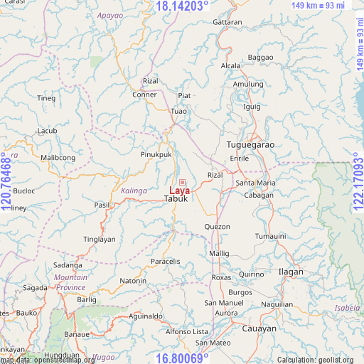
Laya GPS coordinates[2]
17° 28' 21.36" North, 121° 28' 4.08" East
| Map corner | latitude | longitude |
|---|---|---|
| Upper-left | 18.14203°, | 120.76468° |
| Center: | 17.4726°, | 121.4678° |
| Lower-right: | 16.80069°, | 122.17093° |
| Map W x H: | 149.1×149.1 km | = 92.6×92.6mi |
| max Lat: | 20.78733° ⇑4% North |
| Laya: | 17.4726° |
| min Lat: | ⇓96% South 4.65442° |
| min Long | Laya | max Long |
| 117.04868° | 121.4678° | 126.58417° |
| W 32.9%⇐ | ⇒67.1% E |
Elevation
Elevation of Laya is 142 m = 466 ft, and this is 54.1 m = 177 ft above average elevation for this country.
| Max E: |
2262 m = 7421 ft | 14.7% |
| Laya | 142 m 466 ft | |
| Avg. | 87.9 m = 288 ft | |
Min E: |
-2 m = -7 ft | 85.3% |
See also: Philippines elevation on elevation.city.
Geographical zone
Laya is located in North Torrid zone (between Equator and Tropic of Cancer). Distance of this Northern Tropic circle is 663.1 km =412 mi to North.| Distance of | km | miles | from Laya |
|---|---|---|---|
| North Pole | 8064.3 | 5010.9 | to North |
| Arctic Circle | 5458.4 | 3391.7 | to North |
| Tropic Cancer | 663.1 | 412 | to North |
| Equator | 1942.8 | 1207.2 | to South |


Nearby cities:
15 places around Laya: (largest is in red/bold)
• Abut
19.3 km =12 mi,  132°
132°
• Agbannawag
13.7 km =8.5 mi,  141°
141°
• Battung
27.8 km =17.3 mi,  358°
358°
• Dagupan
25.6 km =15.9 mi,  8°
8°
• Enrile
26.2 km =16.3 mi,  68°
68°
• Gadu
23.1 km =14.4 mi,  40°
40°
• Lallayug
26.2 km =16.3 mi,  353°
353°
• Liwan
18.2 km =11.3 mi, 73°
• Maddarulug Norte
26.7 km =16.6 mi,  55°
55°
• Paracelis
22.9 km =14.2 mi,  180°
180°
• Pata
27.2 km =16.9 mi, 7°
• Pinukpuk
17.6 km =10.9 mi,  335°
335°
• Quezon
23.1 km =14.4 mi, 140°
• Tabuk
0.1 km =0.1 mi, 8°
• Tabuk
21.3 km =13.2 mi,  250°
250°
Sources, notices
• [Note1] Compared only with cities in Philippines existing in our database
• [Src1] Map data: © OpenStreetMap contributors (CC-BY-SA)
• [Src2] Other city data from geonames.org with taken over terms of usage.
• [Src3] Geographical zone / Annual Mean Temperature by Robert A. Rohde @ Wikipedia
