Dagupan geodata
Dagupan (Cagayan Valley) is a populated place; located in Philippines in Asia/Manila (GMT+8) time zone. With population of 2,305 people, there are 3670 cities with bigger population in this country. Compared to other cities in Philippines, 97.2% of cities are located further ↓South; 66.4% of cities are located further →East and 64.7% of cities have lower elevation than Dagupan. Note1


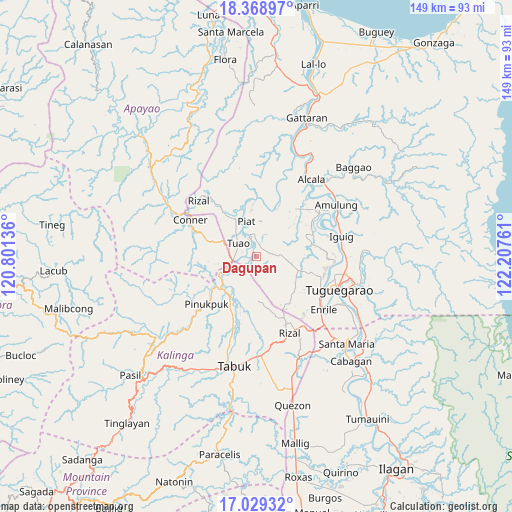
Dagupan GPS coordinates[2]
17° 42' 1.404" North, 121° 30' 16.128" East
| Map corner | latitude | longitude |
|---|---|---|
| Upper-left | 18.36897°, | 120.80136° |
| Center: | 17.70039°, | 121.50448° |
| Lower-right: | 17.02932°, | 122.20761° |
| Map W x H: | 149×149 km | = 92.6×92.6mi |
| max Lat: | 20.78733° ⇑2.8% North |
| Dagupan: | 17.70039° |
| min Lat: | ⇓97.2% South 4.65442° |
| min Long | Dagupan | max Long |
| 117.04868° | 121.50448° | 126.58417° |
| W 33.6%⇐ | ⇒66.4% E |
Elevation
Elevation of Dagupan is 41 m = 135 ft, and this is 46.9 m = 154 ft below average elevation for this country.
| Max E: |
2262 m = 7421 ft | 35.3% |
| Avg. | 87.9 m = 288 ft | |
| Dagupan | 41 m = 135 ft | |
Min E: |
-2 m = -7 ft | 64.7% |
See also: Philippines elevation on elevation.city.
Geographical zone
Dagupan is located in North Torrid zone (between Equator and Tropic of Cancer). Distance of this Northern Tropic circle is 637.8 km =396.3 mi to North.| Distance of | km | miles | from Dagupan |
|---|---|---|---|
| North Pole | 8039 | 4995.2 | to North |
| Arctic Circle | 5433.1 | 3376 | to North |
| Tropic Cancer | 637.8 | 396.3 | to North |
| Equator | 1968.1 | 1222.9 | to South |


Nearby cities:
15 places around Dagupan: (largest is in red/bold)
• Accusilian
6.9 km =4.3 mi,  319°
319°
• Alabug
5.3 km =3.3 mi,  312°
312°
• Atulayan
20.4 km =12.7 mi,  101°
101°
• Bagumbayan
6.6 km =4.1 mi,  292°
292°
• Battung
5.4 km =3.4 mi,  297°
297°
• Bauan
18.8 km =11.7 mi,  82°
82°
• Gadu
13.7 km =8.5 mi,  125°
125°
• Iraga
15.9 km =9.9 mi,  89°
89°
• Lallayug
6.7 km =4.2 mi,  276°
276°
• Maguilling
7.8 km =4.8 mi,  354°
354°
• Mungo
4.4 km =2.7 mi, 306°
• Pata
1.7 km =1.1 mi, 350°
• Piat
10.4 km =6.5 mi,  344°
344°
• Pinukpuk
14.5 km =9 mi,  229°
229°
• Tuao
6.5 km =4 mi, 308°
Sources, notices
• [Note1] Compared only with cities in Philippines existing in our database
• [Src1] Map data: © OpenStreetMap contributors (CC-BY-SA)
• [Src2] Other city data from geonames.org with taken over terms of usage.
• [Src3] Geographical zone / Annual Mean Temperature by Robert A. Rohde @ Wikipedia
