Tabuk geodata
Tabuk (Cordillera) is a seat of a second-order administrative division; located in Philippines in Asia/Manila (GMT+8) time zone. In our database, there are 4166 cities with bigger population. Compared to other cities in Philippines, 95.6% of cities are located further ↓South; 70.5% of cities are located further →East and 92.7% of cities have lower elevation than Tabuk. Note1


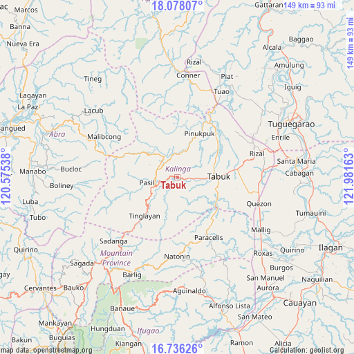
Tabuk GPS coordinates[2]
17° 24' 30.24" North, 121° 16' 42.6" East
| Map corner | latitude | longitude |
|---|---|---|
| Upper-left | 18.07807°, | 120.57538° |
| Center: | 17.4084°, | 121.2785° |
| Lower-right: | 16.73626°, | 121.98163° |
| Map W x H: | 149.2×149.2 km | = 92.7×92.7mi |
| max Lat: | 20.78733° ⇑4.4% North |
| Tabuk: | 17.4084° |
| min Lat: | ⇓95.6% South 4.65442° |
| min Long | Tabuk | max Long |
| 117.04868° | 121.2785° | 126.58417° |
| W 29.5%⇐ | ⇒70.5% E |
Elevation
Elevation of Tabuk is 316 m = 1037 ft, and this is 228.1 m = 748 ft above average elevation for this country.
| Max E: |
2262 m = 7421 ft | 7.3% |
| Tabuk | 316 m 1037 ft | |
| Avg. | 87.9 m = 288 ft | |
Min E: |
-2 m = -7 ft | 92.7% |
See also: Philippines elevation on elevation.city.
Geographical zone
Tabuk is located in North Torrid zone (between Equator and Tropic of Cancer). Distance of this Northern Tropic circle is 670.3 km =416.5 mi to North.| Distance of | km | miles | from Tabuk |
|---|---|---|---|
| North Pole | 8071.4 | 5015.3 | to North |
| Arctic Circle | 5465.5 | 3396.1 | to North |
| Tropic Cancer | 670.3 | 416.5 | to North |
| Equator | 1935.6 | 1202.7 | to South |


Nearby cities:
15 places around Tabuk: (largest is in red/bold)
• Abut
34.8 km =21.6 mi,  99°
99°
• Agbannawag
28.8 km =17.9 mi, 97°
• Balbalan
8.9 km =5.5 mi,  294°
294°
• Butigui
36.5 km =22.7 mi,  153°
153°
• Lallayug
37.4 km =23.2 mi,  27°
27°
• Laya
21.3 km =13.2 mi,  70°
70°
• Lubuagan
12.5 km =7.8 mi,  241°
241°
• Natonin
33.3 km =20.7 mi,  180°
180°
• Paracelis
25.4 km =15.8 mi,  128°
128°
• Pasil
15.7 km =9.8 mi,  259°
259°
• Pinukpuk
26.5 km =16.5 mi, 29°
• Quezon
36.4 km =22.6 mi,  106°
106°
• Tabuk
21.4 km =13.3 mi, 70°
• Tanudan
13.3 km =8.3 mi,  199°
199°
• Tinglayan
19.2 km =11.9 mi,  219°
219°
Sources, notices
• [Note1] Compared only with cities in Philippines existing in our database
• [Src1] Map data: © OpenStreetMap contributors (CC-BY-SA)
• [Src2] Other city data from geonames.org with taken over terms of usage.
• [Src3] Geographical zone / Annual Mean Temperature by Robert A. Rohde @ Wikipedia
