Laiya geodata
Laiya (Calabarzon) is a populated place; located in Philippines in Asia/Manila (GMT+8) time zone. With population of 7,504 people, there are 826 cities with bigger population in this country. Compared to other cities in Philippines, 64.1% of cities are located further ↓South; 68.5% of cities are located further →East and 58.1% of cities have lower elevation than Laiya. Note1


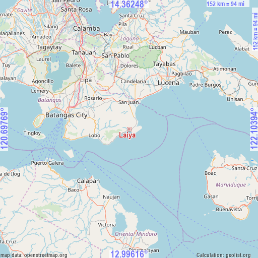
Laiya GPS coordinates[2]
13° 40' 49.116" North, 121° 24' 2.916" East
| Map corner | latitude | longitude |
|---|---|---|
| Upper-left | 14.36248°, | 120.69769° |
| Center: | 13.68031°, | 121.40081° |
| Lower-right: | 12.99616°, | 122.10394° |
| Map W x H: | 151.9×151.9 km | = 94.4×94.4mi |
| max Lat: | 20.78733° ⇑35.9% North |
| Laiya: | 13.68031° |
| min Lat: | ⇓64.1% South 4.65442° |
| min Long | Laiya | max Long |
| 117.04868° | 121.40081° | 126.58417° |
| W 31.5%⇐ | ⇒68.5% E |
Elevation
Elevation of Laiya is 31 m = 102 ft, and this is 56.9 m = 187 ft below average elevation for this country.
| Max E: |
2262 m = 7421 ft | 41.9% |
| Avg. | 87.9 m = 288 ft | |
| Laiya | 31 m = 102 ft | |
Min E: |
-2 m = -7 ft | 58.1% |
See also: Philippines elevation on elevation.city.
Geographical zone
Laiya is located in North Torrid zone (between Equator and Tropic of Cancer). Distance of this Northern Tropic circle is 1084.8 km =674.1 mi to North.| Distance of | km | miles | from Laiya |
|---|---|---|---|
| North Pole | 8486 | 5273 | to North |
| Arctic Circle | 5880.1 | 3653.7 | to North |
| Tropic Cancer | 1084.8 | 674.1 | to North |
| Equator | 1521.1 | 945.2 | to South |


Nearby cities:
15 places around Laiya: (largest is in red/bold)
• Balibago
13.7 km =8.5 mi,  234°
234°
• Calubcub Dos
6.9 km =4.3 mi,  19°
19°
• Libato
16.6 km =10.3 mi,  334°
334°
• Lipahan
17.4 km =10.8 mi,  0°
0°
• Palahanan Uno
17.4 km =10.8 mi,  344°
344°
• Pinagsibaan
19.2 km =11.9 mi, 333°
• Poctol
16.3 km =10.1 mi, 15°
• Pulangbato
8.2 km =5.1 mi,  353°
353°
• Putingkahoy
18.5 km =11.5 mi, 334°
• Quipot
11 km =6.8 mi,  357°
357°
• Sampiro
11.7 km =7.3 mi, 351°
• San Juan
17.1 km =10.6 mi, 359°
• Sico Uno
17 km =10.6 mi, 349°
• Talahiban I
14.2 km =8.8 mi, 351°
• Tipaz
16.7 km =10.4 mi,  9°
9°
Sources, notices
• [Note1] Compared only with cities in Philippines existing in our database
• [Src1] Map data: © OpenStreetMap contributors (CC-BY-SA)
• [Src2] Other city data from geonames.org with taken over terms of usage.
• [Src3] Geographical zone / Annual Mean Temperature by Robert A. Rohde @ Wikipedia
