Kiblawan geodata
Kiblawan (Davao) is a seat of a third-order administrative division; located in Philippines in Asia/Manila (GMT+8) time zone. With population of 4,464 people, there are 1512 cities with bigger population in this country. Compared to other cities in Philippines, 94.9% of cities are located further ↑North; 90.6% of cities are located further ←West and 80.4% of cities have lower elevation than Kiblawan. Note1


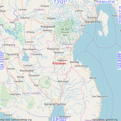
Kiblawan GPS coordinates[2]
6° 36' 51.012" North, 125° 14' 12.012" East
| Map corner | latitude | longitude |
|---|---|---|
| Upper-left | 7.3121°, | 124.53355° |
| Center: | 6.61417°, | 125.23667° |
| Lower-right: | 5.91525°, | 125.9398° |
| Map W x H: | 155.3×155.3 km | = 96.5×96.5mi |
| max Lat: | 20.78733° ⇑94.9% North |
| Kiblawan: | 6.61417° |
| min Lat: | ⇓5.1% South 4.65442° |
| min Long | Kiblawan | max Long |
| 117.04868° | 125.23667° | 126.58417° |
| W 90.6%⇐ | ⇒9.4% E |
Elevation
Elevation of Kiblawan is 94 m = 308 ft, and this is 6.1 m = 20 ft above average elevation for this country.
| Max E: |
2262 m = 7421 ft | 19.6% |
| Kiblawan | 94 m 308 ft | |
| Avg. | 87.9 m = 288 ft | |
Min E: |
-2 m = -7 ft | 80.4% |
See also: Philippines elevation on elevation.city.
Geographical zone
Kiblawan is located in North Torrid zone (between Equator and Tropic of Cancer). Distance of Equator is 735.4 km =457 mi to South.| Distance of | km | miles | from Kiblawan |
|---|---|---|---|
| North Pole | 9271.6 | 5761.1 | to North |
| Arctic Circle | 6665.7 | 4141.9 | to North |
| Tropic Cancer | 1870.5 | 1162.3 | to North |
| Equator | 735.4 | 457 | to South |


Nearby cities:
15 places around Kiblawan: (largest is in red/bold)
• Balutakay
17.4 km =10.8 mi,  46°
46°
• Guihing Proper
15 km =9.3 mi,  58°
58°
• Hagonoy
12.5 km =7.8 mi, 51°
• Ignit
11.4 km =7.1 mi,  32°
32°
• Magsaysay
18 km =11.2 mi,  340°
340°
• Malalag
18.1 km =11.2 mi,  96°
96°
• Malinao
7.5 km =4.7 mi, 47°
• Managa
15.1 km =9.4 mi,  13°
13°
• Matanao
7.5 km =4.7 mi,  15°
15°
• Matti
19.1 km =11.9 mi, 24°
• New Baclayon
15 km =9.3 mi, 102°
• Padada
12.3 km =7.6 mi,  75°
75°
• Sinawilan
15.6 km =9.7 mi,  3°
3°
• Sinayawan
13.6 km =8.5 mi,  36°
36°
• Sulop
11.9 km =7.4 mi, 98°
Sources, notices
• [Note1] Compared only with cities in Philippines existing in our database
• [Src1] Map data: © OpenStreetMap contributors (CC-BY-SA)
• [Src2] Other city data from geonames.org with taken over terms of usage.
• [Src3] Geographical zone / Annual Mean Temperature by Robert A. Rohde @ Wikipedia
