Mileb geodata
Mileb (Autonomous Region in Muslim Mindanao) is a populated place; located in Philippines in Asia/Manila (GMT+8) time zone. With population of 2,758 people, there are 2858 cities with bigger population in this country. Compared to other cities in Philippines, 92.6% of cities are located further ↑North; 80.5% of cities are located further ←West and 62.8% of cities have higher elevation than Mileb. Note1
Administrative division(s):
- Level 1: Autonomous Region in Muslim Mindanao
- Level 2: Province of Maguindanao
- Level 3: Rajah Buayan


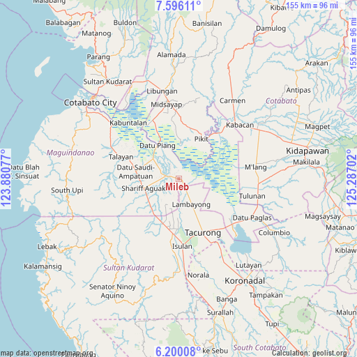
Mileb GPS coordinates[2]
6° 53' 54.996" North, 124° 35' 2.004" East
| Map corner | latitude | longitude |
|---|---|---|
| Upper-left | 7.59611°, | 123.88077° |
| Center: | 6.89861°, | 124.58389° |
| Lower-right: | 6.20008°, | 125.28702° |
| Map W x H: | 155.2×155.2 km | = 96.4×96.4mi |
| max Lat: | 20.78733° ⇑92.6% North |
| Mileb: | 6.89861° |
| min Lat: | ⇓7.4% South 4.65442° |
| min Long | Mileb | max Long |
| 117.04868° | 124.58389° | 126.58417° |
| W 80.5%⇐ | ⇒19.5% E |
Elevation
Elevation of Mileb is 15 m = 49 ft, and this is 72.9 m = 239 ft below average elevation for this country.
| Max E: |
2262 m = 7421 ft | 62.8% |
| Avg. | 87.9 m = 288 ft | |
| Mileb | 15 m = 49 ft | |
Min E: |
-2 m = -7 ft | 37.2% |
See also: Philippines elevation on elevation.city.
Geographical zone
Mileb is located in North Torrid zone (between Equator and Tropic of Cancer). Distance of Equator is 767.1 km =476.7 mi to South.| Distance of | km | miles | from Mileb |
|---|---|---|---|
| North Pole | 9240 | 5741.5 | to North |
| Arctic Circle | 6634.1 | 4122.2 | to North |
| Tropic Cancer | 1838.9 | 1142.6 | to North |
| Equator | 767.1 | 476.7 | to South |


Nearby cities:
15 places around Mileb: (largest is in red/bold)
• Ampatuan
13.4 km =8.3 mi,  254°
254°
• Badak
16.1 km =10 mi,  110°
110°
• Barurao
1.5 km =0.9 mi,  92°
92°
• Damabalas
15.1 km =9.4 mi,  329°
329°
• Kalbugan
10.7 km =6.6 mi,  50°
50°
• Maganoy
16.1 km =10 mi,  256°
256°
• Mamali
15.6 km =9.7 mi,  153°
153°
• Pagatin
14.6 km =9.1 mi,  304°
304°
• Panadtaban
6.5 km =4 mi, 87°
• Pidsandawan
3.8 km =2.4 mi,  11°
11°
• Pimbalayan
10.3 km =6.4 mi, 108°
• Sadsalan
8.2 km =5.1 mi,  160°
160°
• Sagasa
13.9 km =8.6 mi,  184°
184°
• Sambuluan
12.9 km =8 mi,  97°
97°
• Sampao
2.8 km =1.7 mi, 152°
Sources, notices
• [Note1] Compared only with cities in Philippines existing in our database
• [Src1] Map data: © OpenStreetMap contributors (CC-BY-SA)
• [Src2] Other city data from geonames.org with taken over terms of usage.
• [Src3] Geographical zone / Annual Mean Temperature by Robert A. Rohde @ Wikipedia
