Roseller Lim geodata
Roseller Lim (Zamboanga Peninsula) is a seat of a second-order administrative division; located in Philippines in Asia/Manila (GMT+8) time zone. In our database, there are 4166 cities with bigger population. Compared to other cities in Philippines, 85.5% of cities are located further ↑North; 55.4% of cities are located further →East and 57.6% of cities have higher elevation than Roseller Lim. Note1
Administrative division(s):
- Level 1: Zamboanga Peninsula
- Level 2: Province of Zamboanga Sibugay
- Level 3: Roseller Lim


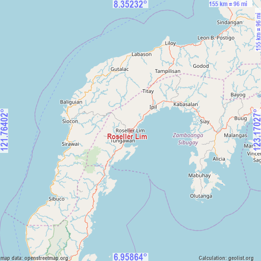
Roseller Lim GPS coordinates[2]
7° 39' 21.78" North, 122° 28' 1.704" East
| Map corner | latitude | longitude |
|---|---|---|
| Upper-left | 8.35232°, | 121.76402° |
| Center: | 7.65605°, | 122.46714° |
| Lower-right: | 6.95864°, | 123.17027° |
| Map W x H: | 155×155 km | = 96.3×96.3mi |
| max Lat: | 20.78733° ⇑85.5% North |
| Roseller Lim: | 7.65605° |
| min Lat: | ⇓14.5% South 4.65442° |
| min Long | Roseller Lim | max Long |
| 117.04868° | 122.46714° | 126.58417° |
| W 44.6%⇐ | ⇒55.4% E |
Elevation
Elevation of Roseller Lim is 18 m = 59 ft, and this is 69.9 m = 229 ft below average elevation for this country.
| Max E: |
2262 m = 7421 ft | 57.6% |
| Avg. | 87.9 m = 288 ft | |
| Roseller Lim | 18 m = 59 ft | |
Min E: |
-2 m = -7 ft | 42.4% |
See also: Philippines elevation on elevation.city.
Geographical zone
Roseller Lim is located in North Torrid zone (between Equator and Tropic of Cancer). Distance of Equator is 851.3 km =529 mi to South.| Distance of | km | miles | from Roseller Lim |
|---|---|---|---|
| North Pole | 9155.8 | 5689.1 | to North |
| Arctic Circle | 6549.9 | 4069.9 | to North |
| Tropic Cancer | 1754.6 | 1090.3 | to North |
| Equator | 851.3 | 529 | to South |


Nearby cities:
15 places around Roseller Lim: (largest is in red/bold)
• Dalangin
24.9 km =15.5 mi,  29°
29°
• Gutalac
36.9 km =22.9 mi,  349°
349°
• Ipil
19.4 km =12.1 mi,  42°
42°
• Kabasalan
36.4 km =22.6 mi,  64°
64°
• Limaong
34.7 km =21.6 mi,  198°
198°
• Naga
33.7 km =20.9 mi,  67°
67°
• Palomoc
31.5 km =19.6 mi,  23°
23°
• Payao
37.8 km =23.5 mi,  101°
101°
• Siocon
37 km =23 mi,  278°
278°
• Siraway
36.9 km =22.9 mi,  257°
257°
• Tigbao
29.6 km =18.4 mi,  211°
211°
• Tigpalay
22.4 km =13.9 mi,  216°
216°
• Titay
18.9 km =11.7 mi, 23°
• Tungawan
19.6 km =12.2 mi, 212°
• Vitali
37.3 km =23.2 mi, 211°
Sources, notices
• [Note1] Compared only with cities in Philippines existing in our database
• [Src1] Map data: © OpenStreetMap contributors (CC-BY-SA)
• [Src2] Other city data from geonames.org with taken over terms of usage.
• [Src3] Geographical zone / Annual Mean Temperature by Robert A. Rohde @ Wikipedia
