Kabungahan geodata
Kabungahan (Central Visayas) is a populated place; located in Philippines in Asia/Manila (GMT+8) time zone. With population of 2,307 people, there are 3666 cities with bigger population in this country. Compared to other cities in Philippines, 63% of cities are located further ↑North; 70.6% of cities are located further ←West and 91.1% of cities have lower elevation than Kabungahan. Note1


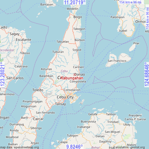
Kabungahan GPS coordinates[2]
10° 31' 0.012" North, 123° 58' 59.988" East
| Map corner | latitude | longitude |
|---|---|---|
| Upper-left | 11.20719°, | 123.28021° |
| Center: | 10.51667°, | 123.98333° |
| Lower-right: | 9.8246°, | 124.68646° |
| Map W x H: | 153.7×153.7 km | = 95.5×95.5mi |
| max Lat: | 20.78733° ⇑63% North |
| Kabungahan: | 10.51667° |
| min Lat: | ⇓37% South 4.65442° |
| min Long | Kabungahan | max Long |
| 117.04868° | 123.98333° | 126.58417° |
| W 70.6%⇐ | ⇒29.4% E |
Elevation
Elevation of Kabungahan is 258 m = 846 ft, and this is 170.1 m = 558 ft above average elevation for this country.
| Max E: |
2262 m = 7421 ft | 8.9% |
| Kabungahan | 258 m 846 ft | |
| Avg. | 87.9 m = 288 ft | |
Min E: |
-2 m = -7 ft | 91.1% |
See also: Philippines elevation on elevation.city.
Geographical zone
Kabungahan is located in North Torrid zone (between Equator and Tropic of Cancer). Distance of Equator is 1169.3 km =726.6 mi to South.| Distance of | km | miles | from Kabungahan |
|---|---|---|---|
| North Pole | 8837.7 | 5491.5 | to North |
| Arctic Circle | 6231.8 | 3872.3 | to North |
| Tropic Cancer | 1436.6 | 892.7 | to North |
| Equator | 1169.3 | 726.6 | to South |


Nearby cities:
15 places around Kabungahan: (largest is in red/bold)
• Agsungot
12.4 km =7.7 mi,  222°
222°
• Cambanay
3 km =1.9 mi,  5°
5°
• Cogan
9.3 km =5.8 mi,  23°
23°
• Cogon Cruz
1.7 km =1.1 mi,  241°
241°
• Compostela
7.5 km =4.7 mi,  156°
156°
• Consolacion
15.8 km =9.8 mi,  190°
190°
• Danao
4.8 km =3 mi,  84°
84°
• Kotkot
10.4 km =6.5 mi,  169°
169°
• Liloan
13.2 km =8.2 mi, 172°
• Magay
6 km =3.7 mi,  146°
146°
• Masaba
2.6 km =1.6 mi,  315°
315°
• Nangka
4.1 km =2.5 mi,  333°
333°
• Panalipan
15.2 km =9.4 mi, 15°
• Sandayong Sur
2.9 km =1.8 mi,  143°
143°
• Tayud
15.4 km =9.6 mi, 171°
Sources, notices
• [Note1] Compared only with cities in Philippines existing in our database
• [Src1] Map data: © OpenStreetMap contributors (CC-BY-SA)
• [Src2] Other city data from geonames.org with taken over terms of usage.
• [Src3] Geographical zone / Annual Mean Temperature by Robert A. Rohde @ Wikipedia
