Magay geodata
Magay (Central Visayas) is a populated place; located in Philippines in Asia/Manila (GMT+8) time zone. With population of 2,281 people, there are 3719 cities with bigger population in this country. Compared to other cities in Philippines, 63.5% of cities are located further ↑North; 71.3% of cities are located further ←West and 89.7% of cities have higher elevation than Magay. Note1


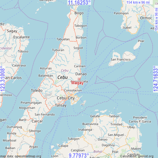
Magay GPS coordinates[2]
10° 28' 18.84" North, 124° 0' 47.52" East
| Map corner | latitude | longitude |
|---|---|---|
| Upper-left | 11.16253°, | 123.31008° |
| Center: | 10.4719°, | 124.0132° |
| Lower-right: | 9.77973°, | 124.71633° |
| Map W x H: | 153.8×153.8 km | = 95.6×95.6mi |
| max Lat: | 20.78733° ⇑63.5% North |
| Magay: | 10.4719° |
| min Lat: | ⇓36.5% South 4.65442° |
| min Long | Magay | max Long |
| 117.04868° | 124.0132° | 126.58417° |
| W 71.3%⇐ | ⇒28.7% E |
Elevation
Elevation of Magay is 7 m = 23 ft, and this is 80.9 m = 265 ft below average elevation for this country.
| Max E: |
2262 m = 7421 ft | 89.7% |
| Avg. | 87.9 m = 288 ft | |
| Magay | 7 m = 23 ft | |
Min E: |
-2 m = -7 ft | 10.3% |
See also: Philippines elevation on elevation.city.
Geographical zone
Magay is located in North Torrid zone (between Equator and Tropic of Cancer). Distance of Equator is 1164.4 km =723.5 mi to South.| Distance of | km | miles | from Magay |
|---|---|---|---|
| North Pole | 8842.7 | 5494.6 | to North |
| Arctic Circle | 6236.8 | 3875.4 | to North |
| Tropic Cancer | 1441.6 | 895.8 | to North |
| Equator | 1164.4 | 723.5 | to South |


Nearby cities:
15 places around Magay: (largest is in red/bold)
• Agsungot
12.4 km =7.7 mi,  250°
250°
• Calero
11.1 km =6.9 mi,  188°
188°
• Cambanay
8.5 km =5.3 mi,  339°
339°
• Cogan
13.5 km =8.4 mi,  2°
2°
• Cogon Cruz
6.3 km =3.9 mi,  311°
311°
• Compostela
1.9 km =1.2 mi, 188°
• Consolacion
12.2 km =7.6 mi,  209°
209°
• Danao
5.7 km =3.5 mi,  15°
15°
• Kabungahan
6 km =3.7 mi,  326°
326°
• Kotkot
5.4 km =3.4 mi, 194°
• Liloan
8.2 km =5.1 mi, 190°
• Masaba
8.5 km =5.3 mi,  323°
323°
• Nangka
10.1 km =6.3 mi, 329°
• Sandayong Sur
3.1 km =1.9 mi, 329°
• Tayud
10.3 km =6.4 mi,  184°
184°
Sources, notices
• [Note1] Compared only with cities in Philippines existing in our database
• [Src1] Map data: © OpenStreetMap contributors (CC-BY-SA)
• [Src2] Other city data from geonames.org with taken over terms of usage.
• [Src3] Geographical zone / Annual Mean Temperature by Robert A. Rohde @ Wikipedia
