Cambanay geodata
Cambanay (Central Visayas) is a populated place; located in Philippines in Asia/Manila (GMT+8) time zone. With population of 2,658 people, there are 3019 cities with bigger population in this country. Compared to other cities in Philippines, 62.7% of cities are located further ↑North; 70.7% of cities are located further ←West and 89.9% of cities have lower elevation than Cambanay. Note1


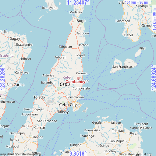
Cambanay GPS coordinates[2]
10° 32' 36.996" North, 123° 59' 9.996" East
| Map corner | latitude | longitude |
|---|---|---|
| Upper-left | 11.23407°, | 123.28299° |
| Center: | 10.54361°, | 123.98611° |
| Lower-right: | 9.8516°, | 124.68924° |
| Map W x H: | 153.7×153.7 km | = 95.5×95.5mi |
| max Lat: | 20.78733° ⇑62.7% North |
| Cambanay: | 10.54361° |
| min Lat: | ⇓37.3% South 4.65442° |
| min Long | Cambanay | max Long |
| 117.04868° | 123.98611° | 126.58417° |
| W 70.7%⇐ | ⇒29.3% E |
Elevation
Elevation of Cambanay is 225 m = 738 ft, and this is 137.1 m = 450 ft above average elevation for this country.
| Max E: |
2262 m = 7421 ft | 10.1% |
| Cambanay | 225 m 738 ft | |
| Avg. | 87.9 m = 288 ft | |
Min E: |
-2 m = -7 ft | 89.9% |
See also: Philippines elevation on elevation.city.
Geographical zone
Cambanay is located in North Torrid zone (between Equator and Tropic of Cancer). Distance of Equator is 1172.3 km =728.4 mi to South.| Distance of | km | miles | from Cambanay |
|---|---|---|---|
| North Pole | 8834.7 | 5489.6 | to North |
| Arctic Circle | 6228.8 | 3870.4 | to North |
| Tropic Cancer | 1433.6 | 890.8 | to North |
| Equator | 1172.3 | 728.4 | to South |


Nearby cities:
15 places around Cambanay: (largest is in red/bold)
• Agsungot
15 km =9.3 mi,  215°
215°
• Catmondaan
16.2 km =10.1 mi,  11°
11°
• Cogan
6.5 km =4 mi,  32°
32°
• Cogon Cruz
4.2 km =2.6 mi,  205°
205°
• Compostela
10.2 km =6.3 mi,  164°
164°
• Danao
5.2 km =3.2 mi,  119°
119°
• Kabungahan
3 km =1.9 mi,  185°
185°
• Kotkot
13.3 km =8.3 mi,  173°
173°
• Liloan
16.1 km =10 mi, 174°
• Macaas
17.5 km =10.9 mi, 9°
• Magay
8.5 km =5.3 mi, 159°
• Masaba
2.4 km =1.5 mi,  241°
241°
• Nangka
2.2 km =1.4 mi,  288°
288°
• Panalipan
12.3 km =7.6 mi,  18°
18°
• Sandayong Sur
5.5 km =3.4 mi, 165°
Sources, notices
• [Note1] Compared only with cities in Philippines existing in our database
• [Src1] Map data: © OpenStreetMap contributors (CC-BY-SA)
• [Src2] Other city data from geonames.org with taken over terms of usage.
• [Src3] Geographical zone / Annual Mean Temperature by Robert A. Rohde @ Wikipedia
