Cogan geodata
Cogan (Central Visayas) is a populated place; located in Philippines in Asia/Manila (GMT+8) time zone. With population of 21,898 people, there are 352 cities with bigger population in this country. Compared to other cities in Philippines, 62.1% of cities are located further ↑North; 71.4% of cities are located further ←West and 67.4% of cities have higher elevation than Cogan. Note1


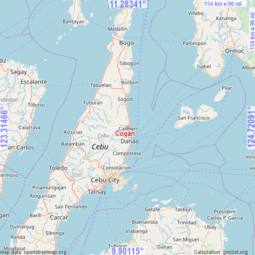
Cogan GPS coordinates[2]
10° 35' 35.016" North, 124° 1' 4.008" East
| Map corner | latitude | longitude |
|---|---|---|
| Upper-left | 11.28341°, | 123.31466° |
| Center: | 10.59306°, | 124.01778° |
| Lower-right: | 9.90115°, | 124.72091° |
| Map W x H: | 153.7×153.7 km | = 95.5×95.5mi |
| max Lat: | 20.78733° ⇑62.1% North |
| Cogan: | 10.59306° |
| min Lat: | ⇓37.9% South 4.65442° |
| min Long | Cogan | max Long |
| 117.04868° | 124.01778° | 126.58417° |
| W 71.4%⇐ | ⇒28.6% E |
Elevation
Elevation of Cogan is 13 m = 43 ft, and this is 74.9 m = 246 ft below average elevation for this country.
| Max E: |
2262 m = 7421 ft | 67.4% |
| Avg. | 87.9 m = 288 ft | |
| Cogan | 13 m = 43 ft | |
Min E: |
-2 m = -7 ft | 32.6% |
See also: Philippines elevation on elevation.city.
Geographical zone
Cogan is located in North Torrid zone (between Equator and Tropic of Cancer). Distance of Equator is 1177.8 km =731.9 mi to South.| Distance of | km | miles | from Cogan |
|---|---|---|---|
| North Pole | 8829.2 | 5486.2 | to North |
| Arctic Circle | 6223.3 | 3867 | to North |
| Tropic Cancer | 1428.1 | 887.4 | to North |
| Equator | 1177.8 | 731.9 | to South |


Nearby cities:
15 places around Cogan: (largest is in red/bold)
• Cabalawan
18 km =11.2 mi,  336°
336°
• Cambanay
6.5 km =4 mi,  212°
212°
• Catmon
13.9 km =8.6 mi,  351°
351°
• Catmondaan
10.4 km =6.5 mi,  358°
358°
• Cogon Cruz
10.7 km =6.6 mi, 209°
• Compostela
15.4 km =9.6 mi,  182°
182°
• Danao
8.1 km =5 mi,  172°
172°
• Kabungahan
9.3 km =5.8 mi,  203°
203°
• Macaas
11.8 km =7.3 mi, 356°
• Magay
13.5 km =8.4 mi, 182°
• Masaba
8.7 km =5.4 mi,  220°
220°
• Nangka
7.4 km =4.6 mi,  229°
229°
• Panalipan
6.2 km =3.9 mi,  3°
3°
• Sandayong Sur
11 km =6.8 mi,  190°
190°
• Sogod
17.7 km =11 mi, 351°
Sources, notices
• [Note1] Compared only with cities in Philippines existing in our database
• [Src1] Map data: © OpenStreetMap contributors (CC-BY-SA)
• [Src2] Other city data from geonames.org with taken over terms of usage.
• [Src3] Geographical zone / Annual Mean Temperature by Robert A. Rohde @ Wikipedia
