Tayud geodata
Tayud (Central Visayas) is a populated place; located in Philippines in Asia/Manila (GMT+8) time zone. With population of 7,788 people, there are 797 cities with bigger population in this country. Compared to other cities in Philippines, 64.3% of cities are located further ↑North; 71% of cities are located further ←West and 70.2% of cities have higher elevation than Tayud. Note1


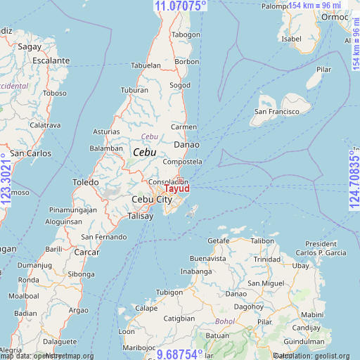
Tayud GPS coordinates[2]
10° 22' 47.676" North, 124° 0' 18.792" East
| Map corner | latitude | longitude |
|---|---|---|
| Upper-left | 11.07075°, | 123.3021° |
| Center: | 10.37991°, | 124.00522° |
| Lower-right: | 9.68754°, | 124.70835° |
| Map W x H: | 153.8×153.8 km | = 95.6×95.6mi |
| max Lat: | 20.78733° ⇑64.3% North |
| Tayud: | 10.37991° |
| min Lat: | ⇓35.7% South 4.65442° |
| min Long | Tayud | max Long |
| 117.04868° | 124.00522° | 126.58417° |
| W 71%⇐ | ⇒29% E |
Elevation
Elevation of Tayud is 12 m = 39 ft, and this is 75.9 m = 249 ft below average elevation for this country.
| Max E: |
2262 m = 7421 ft | 70.2% |
| Avg. | 87.9 m = 288 ft | |
| Tayud | 12 m = 39 ft | |
Min E: |
-2 m = -7 ft | 29.8% |
See also: Philippines elevation on elevation.city.
Geographical zone
Tayud is located in North Torrid zone (between Equator and Tropic of Cancer). Distance of Equator is 1154.1 km =717.1 mi to South.| Distance of | km | miles | from Tayud |
|---|---|---|---|
| North Pole | 8852.9 | 5500.9 | to North |
| Arctic Circle | 6247 | 3881.7 | to North |
| Tropic Cancer | 1451.8 | 902.1 | to North |
| Equator | 1154.1 | 717.1 | to South |


Nearby cities:
15 places around Tayud: (largest is in red/bold)
• Agsungot
12.4 km =7.7 mi,  299°
299°
• Apas
12 km =7.5 mi,  248°
248°
• Baugo
11.7 km =7.3 mi,  233°
233°
• Calero
1.1 km =0.7 mi, 227°
• Cebu City
14.4 km =8.9 mi,  240°
240°
• Compostela
8.4 km =5.2 mi,  4°
4°
• Consolacion
5.3 km =3.3 mi,  265°
265°
• Dapitan
14.4 km =8.9 mi,  204°
204°
• Gabi
13.8 km =8.6 mi, 200°
• Kotkot
5 km =3.1 mi,  354°
354°
• Lapu-Lapu City
9.9 km =6.2 mi,  218°
218°
• Liloan
2.2 km =1.4 mi,  342°
342°
• Magay
10.3 km =6.4 mi, 4°
• Mandaue City
11 km =6.8 mi, 235°
• Sandayong Sur
12.9 km =8 mi,  356°
356°
Sources, notices
• [Note1] Compared only with cities in Philippines existing in our database
• [Src1] Map data: © OpenStreetMap contributors (CC-BY-SA)
• [Src2] Other city data from geonames.org with taken over terms of usage.
• [Src3] Geographical zone / Annual Mean Temperature by Robert A. Rohde @ Wikipedia
