Kabugao geodata
Kabugao (Cordillera) is a seat of a third-order administrative division; located in Philippines in Asia/Manila (GMT+8) time zone. With population of 2,337 people, there are 3592 cities with bigger population in this country. Compared to other cities in Philippines, 98.2% of cities are located further ↓South; 72% of cities are located further →East and 81.5% of cities have lower elevation than Kabugao. Note1


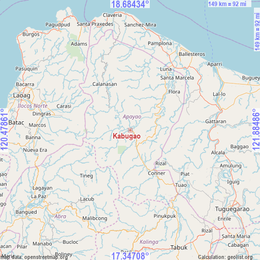
Kabugao GPS coordinates[2]
18° 1' 1.128" North, 121° 10' 54.228" East
| Map corner | latitude | longitude |
|---|---|---|
| Upper-left | 18.68434°, | 120.47861° |
| Center: | 18.01698°, | 121.18173° |
| Lower-right: | 17.34708°, | 121.88486° |
| Map W x H: | 148.7×148.7 km | = 92.4×92.4mi |
| max Lat: | 20.78733° ⇑1.8% North |
| Kabugao: | 18.01698° |
| min Lat: | ⇓98.2% South 4.65442° |
| min Long | Kabugao | max Long |
| 117.04868° | 121.18173° | 126.58417° |
| W 28%⇐ | ⇒72% E |
Elevation
Elevation of Kabugao is 103 m = 338 ft, and this is 15.1 m = 50 ft above average elevation for this country.
| Max E: |
2262 m = 7421 ft | 18.5% |
| Kabugao | 103 m 338 ft | |
| Avg. | 87.9 m = 288 ft | |
Min E: |
-2 m = -7 ft | 81.5% |
See also: Philippines elevation on elevation.city.
Geographical zone
Kabugao is located in North Torrid zone (between Equator and Tropic of Cancer). Distance of this Northern Tropic circle is 602.6 km =374.4 mi to North.| Distance of | km | miles | from Kabugao |
|---|---|---|---|
| North Pole | 8003.8 | 4973.3 | to North |
| Arctic Circle | 5397.9 | 3354.1 | to North |
| Tropic Cancer | 602.6 | 374.4 | to North |
| Equator | 2003.3 | 1244.8 | to South |


Nearby cities:
15 places around Kabugao: (largest is in red/bold)
• Accusilian
42.2 km =26.2 mi,  135°
135°
• Alannay
43 km =26.7 mi,  83°
83°
• Bagumbayan
43.1 km =26.8 mi, 139°
• Calanasan
30.7 km =19.1 mi,  329°
329°
• Carasi
38.8 km =24.1 mi,  301°
301°
• Conner
29 km =18 mi,  147°
147°
• Flora
33.4 km =20.8 mi,  48°
48°
• Luna
38.8 km =24.1 mi,  27°
27°
• Maguilling
43.3 km =26.9 mi,  129°
129°
• Nabannagan West
38 km =23.6 mi, 80°
• Piat
40.2 km =25 mi, 128°
• Rizal
25.6 km =15.9 mi, 137°
• Santa Marcela
39.8 km =24.7 mi,  41°
41°
• Santo Niño
43.5 km =27 mi,  109°
109°
• Tuao
42.6 km =26.5 mi, 137°
Sources, notices
• [Note1] Compared only with cities in Philippines existing in our database
• [Src1] Map data: © OpenStreetMap contributors (CC-BY-SA)
• [Src2] Other city data from geonames.org with taken over terms of usage.
• [Src3] Geographical zone / Annual Mean Temperature by Robert A. Rohde @ Wikipedia
