Rizal geodata
Rizal (Cagayan Valley) is a seat of a third-order administrative division; located in Philippines in Asia/Manila (GMT+8) time zone. In our database, there are 4166 cities with bigger population. Compared to other cities in Philippines, 97.8% of cities are located further ↓South; 69.4% of cities are located further →East and 79.4% of cities have lower elevation than Rizal. Note1


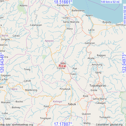
Rizal GPS coordinates[2]
17° 50' 54.96" North, 121° 20' 47.76" East
| Map corner | latitude | longitude |
|---|---|---|
| Upper-left | 18.51661°, | 120.64348° |
| Center: | 17.8486°, | 121.3466° |
| Lower-right: | 17.17807°, | 122.04973° |
| Map W x H: | 148.8×148.8 km | = 92.5×92.5mi |
| max Lat: | 20.78733° ⇑2.2% North |
| Rizal: | 17.8486° |
| min Lat: | ⇓97.8% South 4.65442° |
| min Long | Rizal | max Long |
| 117.04868° | 121.3466° | 126.58417° |
| W 30.6%⇐ | ⇒69.4% E |
Elevation
Elevation of Rizal is 88 m = 289 ft, and this is 0.099999999999994 m = 0 ft above average elevation for this country.
| Max E: |
2262 m = 7421 ft | 20.6% |
| Rizal | 88 m 289 ft | |
| Avg. | 87.9 m = 288 ft | |
Min E: |
-2 m = -7 ft | 79.4% |
See also: Philippines elevation on elevation.city.
Geographical zone
Rizal is located in North Torrid zone (between Equator and Tropic of Cancer). Distance of this Northern Tropic circle is 621.3 km =386.1 mi to North.| Distance of | km | miles | from Rizal |
|---|---|---|---|
| North Pole | 8022.5 | 4984.9 | to North |
| Arctic Circle | 5416.6 | 3365.7 | to North |
| Tropic Cancer | 621.3 | 386.1 | to North |
| Equator | 1984.6 | 1233.2 | to South |


Nearby cities:
15 places around Rizal: (largest is in red/bold)
• Accusilian
16.6 km =10.3 mi,  132°
132°
• Alabug
18.2 km =11.3 mi,  135°
135°
• Bagumbayan
17.6 km =10.9 mi, 142°
• Battung
18.4 km =11.4 mi, 139°
• Conner
6.1 km =3.8 mi,  199°
199°
• Dagupan
23.5 km =14.6 mi, 134°
• Kabugao
25.6 km =15.9 mi,  317°
317°
• Lallayug
18.7 km =11.6 mi,  147°
147°
• Maguilling
18.2 km =11.3 mi,  118°
118°
• Mungo
19.1 km =11.9 mi, 136°
• Pata
22.1 km =13.7 mi, 132°
• Piat
15.3 km =9.5 mi,  114°
114°
• Pinukpuk
26.4 km =16.4 mi,  167°
167°
• Santo Niño
23.9 km =14.9 mi,  79°
79°
• Tuao
17 km =10.6 mi, 137°
Sources, notices
• [Note1] Compared only with cities in Philippines existing in our database
• [Src1] Map data: © OpenStreetMap contributors (CC-BY-SA)
• [Src2] Other city data from geonames.org with taken over terms of usage.
• [Src3] Geographical zone / Annual Mean Temperature by Robert A. Rohde @ Wikipedia
