Maguilling geodata
Maguilling (Cagayan Valley) is a populated place; located in Philippines in Asia/Manila (GMT+8) time zone. With population of 2,892 people, there are 2655 cities with bigger population in this country. Compared to other cities in Philippines, 97.7% of cities are located further ↓South; 66.6% of cities are located further →East and 62.2% of cities have lower elevation than Maguilling. Note1


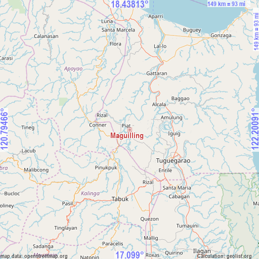
Maguilling GPS coordinates[2]
17° 46' 11.352" North, 121° 29' 52.008" East
| Map corner | latitude | longitude |
|---|---|---|
| Upper-left | 18.43813°, | 120.79466° |
| Center: | 17.76982°, | 121.49778° |
| Lower-right: | 17.099°, | 122.20091° |
| Map W x H: | 148.9×148.9 km | = 92.5×92.5mi |
| max Lat: | 20.78733° ⇑2.3% North |
| Maguilling: | 17.76982° |
| min Lat: | ⇓97.7% South 4.65442° |
| min Long | Maguilling | max Long |
| 117.04868° | 121.49778° | 126.58417° |
| W 33.4%⇐ | ⇒66.6% E |
Elevation
Elevation of Maguilling is 37 m = 121 ft, and this is 50.9 m = 167 ft below average elevation for this country.
| Max E: |
2262 m = 7421 ft | 37.8% |
| Avg. | 87.9 m = 288 ft | |
| Maguilling | 37 m = 121 ft | |
Min E: |
-2 m = -7 ft | 62.2% |
See also: Philippines elevation on elevation.city.
Geographical zone
Maguilling is located in North Torrid zone (between Equator and Tropic of Cancer). Distance of this Northern Tropic circle is 630.1 km =391.5 mi to North.| Distance of | km | miles | from Maguilling |
|---|---|---|---|
| North Pole | 8031.2 | 4990.4 | to North |
| Arctic Circle | 5425.4 | 3371.2 | to North |
| Tropic Cancer | 630.1 | 391.5 | to North |
| Equator | 1975.8 | 1227.7 | to South |


Nearby cities:
15 places around Maguilling: (largest is in red/bold)
• Accusilian
4.5 km =2.8 mi,  236°
236°
• Afusing Centro
16.5 km =10.3 mi,  56°
56°
• Alabug
5.2 km =3.2 mi,  217°
217°
• Bagumbayan
7.5 km =4.7 mi,  225°
225°
• Battung
6.7 km =4.2 mi, 217°
• Conner
18.3 km =11.4 mi,  279°
279°
• Dagupan
7.8 km =4.8 mi,  174°
174°
• Iraga
18.3 km =11.4 mi,  114°
114°
• Lallayug
9.2 km =5.7 mi, 220°
• Mungo
5.8 km =3.6 mi,  209°
209°
• Pata
6.1 km =3.8 mi,  175°
175°
• Piat
3.1 km =1.9 mi,  317°
317°
• Rizal
18.2 km =11.3 mi,  298°
298°
• Santo Niño
15 km =9.3 mi,  30°
30°
• Tuao
5.7 km =3.5 mi, 229°
Sources, notices
• [Note1] Compared only with cities in Philippines existing in our database
• [Src1] Map data: © OpenStreetMap contributors (CC-BY-SA)
• [Src2] Other city data from geonames.org with taken over terms of usage.
• [Src3] Geographical zone / Annual Mean Temperature by Robert A. Rohde @ Wikipedia
