Bugho geodata
Bugho (Eastern Visayas) is a populated place; located in Philippines in Asia/Manila (GMT+8) time zone. With population of 2,948 people, there are 2589 cities with bigger population in this country. Compared to other cities in Philippines, 59.6% of cities are located further ↑North; 86.6% of cities are located further ←West and 61.5% of cities have lower elevation than Bugho. Note1
Administrative division(s):
- Level 1: Eastern Visayas
- Level 2: Province of Leyte
- Level 3: Javier (Bugho)


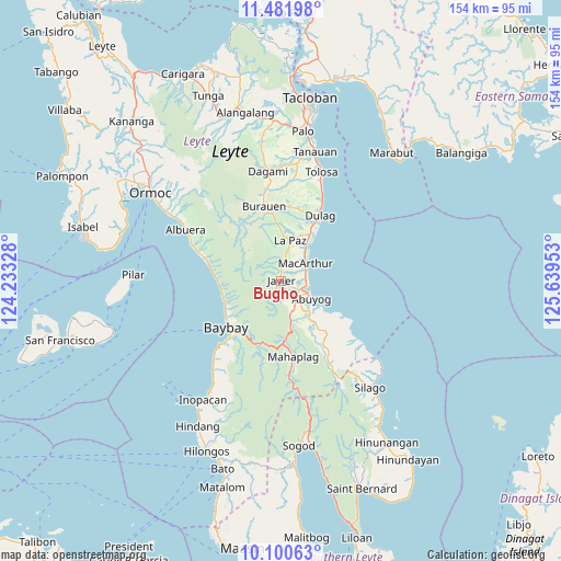
Bugho GPS coordinates[2]
10° 47' 31.56" North, 124° 56' 11.04" East
| Map corner | latitude | longitude |
|---|---|---|
| Upper-left | 11.48198°, | 124.23328° |
| Center: | 10.7921°, | 124.9364° |
| Lower-right: | 10.10063°, | 125.63953° |
| Map W x H: | 153.6×153.6 km | = 95.4×95.4mi |
| max Lat: | 20.78733° ⇑59.6% North |
| Bugho: | 10.7921° |
| min Lat: | ⇓40.4% South 4.65442° |
| min Long | Bugho | max Long |
| 117.04868° | 124.9364° | 126.58417° |
| W 86.6%⇐ | ⇒13.4% E |
Elevation
Elevation of Bugho is 36 m = 118 ft, and this is 51.9 m = 170 ft below average elevation for this country.
| Max E: |
2262 m = 7421 ft | 38.5% |
| Avg. | 87.9 m = 288 ft | |
| Bugho | 36 m = 118 ft | |
Min E: |
-2 m = -7 ft | 61.5% |
See also: Philippines elevation on elevation.city.
Geographical zone
Bugho is located in North Torrid zone (between Equator and Tropic of Cancer). Distance of Equator is 1200 km =745.6 mi to South.| Distance of | km | miles | from Bugho |
|---|---|---|---|
| North Pole | 8807.1 | 5472.5 | to North |
| Arctic Circle | 6201.2 | 3853.2 | to North |
| Tropic Cancer | 1405.9 | 873.6 | to North |
| Equator | 1200 | 745.6 | to South |


Nearby cities:
15 places around Bugho: (largest is in red/bold)
• Abuyog
9.5 km =5.9 mi,  121°
121°
• Balinsacayao
12.6 km =7.8 mi,  168°
168°
• Balocawehay
8.5 km =5.3 mi,  156°
156°
• Baybay
19.5 km =12.1 mi,  229°
229°
• Bunga
16.7 km =10.4 mi,  262°
262°
• Cabacuñgan
16.5 km =10.3 mi,  17°
17°
• Dulag
20.6 km =12.8 mi,  30°
30°
• Gabas
16.8 km =10.4 mi,  245°
245°
• Hipasngo
20.1 km =12.5 mi,  224°
224°
• Julita
20.5 km =12.7 mi,  7°
7°
• Kilim
17.7 km =11 mi,  239°
239°
• La Paz
11.4 km =7.1 mi, 10°
• Liberty
11.6 km =7.2 mi,  38°
38°
• MacArthur
8 km =5 mi,  53°
53°
• Mayorga
13.9 km =8.6 mi, 30°
Sources, notices
• [Note1] Compared only with cities in Philippines existing in our database
• [Src1] Map data: © OpenStreetMap contributors (CC-BY-SA)
• [Src2] Other city data from geonames.org with taken over terms of usage.
• [Src3] Geographical zone / Annual Mean Temperature by Robert A. Rohde @ Wikipedia
