Igang geodata
Igang (Western Visayas) is a populated place; located in Philippines in Asia/Manila (GMT+8) time zone. With population of 3,468 people, there are 2082 cities with bigger population in this country. Compared to other cities in Philippines, 57.8% of cities are located further ↑North; 52.3% of cities are located further →East and 54.4% of cities have lower elevation than Igang. Note1


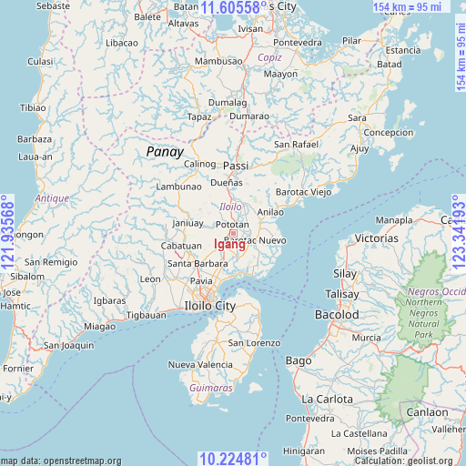
Igang GPS coordinates[2]
10° 54' 57.6" North, 122° 38' 19.68" East
| Map corner | latitude | longitude |
|---|---|---|
| Upper-left | 11.60558°, | 121.93568° |
| Center: | 10.916°, | 122.6388° |
| Lower-right: | 10.22481°, | 123.34193° |
| Map W x H: | 153.5×153.5 km | = 95.4×95.4mi |
| max Lat: | 20.78733° ⇑57.8% North |
| Igang: | 10.916° |
| min Lat: | ⇓42.2% South 4.65442° |
| min Long | Igang | max Long |
| 117.04868° | 122.6388° | 126.58417° |
| W 47.7%⇐ | ⇒52.3% E |
Elevation
Elevation of Igang is 27 m = 89 ft, and this is 60.9 m = 200 ft below average elevation for this country.
| Max E: |
2262 m = 7421 ft | 45.6% |
| Avg. | 87.9 m = 288 ft | |
| Igang | 27 m = 89 ft | |
Min E: |
-2 m = -7 ft | 54.4% |
See also: Philippines elevation on elevation.city.
Geographical zone
Igang is located in North Torrid zone (between Equator and Tropic of Cancer). Distance of Equator is 1213.7 km =754.2 mi to South.| Distance of | km | miles | from Igang |
|---|---|---|---|
| North Pole | 8793.3 | 5463.9 | to North |
| Arctic Circle | 6187.4 | 3844.7 | to North |
| Tropic Cancer | 1392.2 | 865.1 | to North |
| Equator | 1213.7 | 754.2 | to South |


Nearby cities:
15 places around Igang: (largest is in red/bold)
• Abangay
5.8 km =3.6 mi,  12°
12°
• Barotac Nuevo
7.6 km =4.7 mi,  108°
108°
• Cabilauan
3.5 km =2.2 mi,  139°
139°
• Dingle
9.9 km =6.2 mi,  20°
20°
• Ermita
8.7 km =5.4 mi,  101°
101°
• Jalaud
8.1 km =5 mi,  178°
178°
• Jamabalod
4.6 km =2.9 mi,  204°
204°
• Kabilauan
9.4 km =5.8 mi,  229°
229°
• Lucena
6.1 km =3.8 mi, 228°
• Mina
7.2 km =4.5 mi,  283°
283°
• Monpon
0.5 km =0.3 mi,  193°
193°
• Pasil
9.3 km =5.8 mi, 200°
• Pototan
3.1 km =1.9 mi,  352°
352°
• Tiwi
10.5 km =6.5 mi,  81°
81°
• Tumcon Ilawod
3 km =1.9 mi,  88°
88°
Sources, notices
• [Note1] Compared only with cities in Philippines existing in our database
• [Src1] Map data: © OpenStreetMap contributors (CC-BY-SA)
• [Src2] Other city data from geonames.org with taken over terms of usage.
• [Src3] Geographical zone / Annual Mean Temperature by Robert A. Rohde @ Wikipedia
