Mina geodata
Mina (Western Visayas) is a seat of a third-order administrative division; located in Philippines in Asia/Manila (GMT+8) time zone. With population of 2,665 people, there are 3010 cities with bigger population in this country. Compared to other cities in Philippines, 57.6% of cities are located further ↑North; 53.3% of cities are located further →East and 65.2% of cities have lower elevation than Mina. Note1


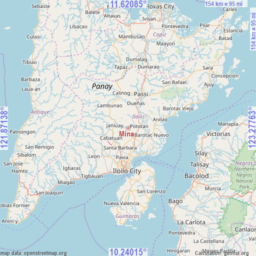
Mina GPS coordinates[2]
10° 55' 52.68" North, 122° 34' 28.2" East
| Map corner | latitude | longitude |
|---|---|---|
| Upper-left | 11.62085°, | 121.87138° |
| Center: | 10.9313°, | 122.5745° |
| Lower-right: | 10.24015°, | 123.27763° |
| Map W x H: | 153.5×153.5 km | = 95.4×95.4mi |
| max Lat: | 20.78733° ⇑57.6% North |
| Mina: | 10.9313° |
| min Lat: | ⇓42.4% South 4.65442° |
| min Long | Mina | max Long |
| 117.04868° | 122.5745° | 126.58417° |
| W 46.7%⇐ | ⇒53.3% E |
Elevation
Elevation of Mina is 42 m = 138 ft, and this is 45.9 m = 151 ft below average elevation for this country.
| Max E: |
2262 m = 7421 ft | 34.8% |
| Avg. | 87.9 m = 288 ft | |
| Mina | 42 m = 138 ft | |
Min E: |
-2 m = -7 ft | 65.2% |
See also: Philippines elevation on elevation.city.
Geographical zone
Mina is located in North Torrid zone (between Equator and Tropic of Cancer). Distance of Equator is 1215.4 km =755.2 mi to South.| Distance of | km | miles | from Mina |
|---|---|---|---|
| North Pole | 8791.6 | 5462.8 | to North |
| Arctic Circle | 6185.7 | 3843.6 | to North |
| Tropic Cancer | 1390.5 | 864 | to North |
| Equator | 1215.4 | 755.2 | to South |


Nearby cities:
15 places around Mina: (largest is in red/bold)
• Abangay
9.1 km =5.7 mi,  64°
64°
• Badiangan
11.6 km =7.2 mi,  315°
315°
• Binabaan
11.3 km =7 mi,  329°
329°
• Cabatuan
11.3 km =7 mi,  239°
239°
• Cabilauan
10.2 km =6.3 mi,  115°
115°
• Gines-Patay
8.9 km =5.5 mi,  273°
273°
• Igang
7.2 km =4.5 mi,  103°
103°
• Jamabalod
7.8 km =4.8 mi,  138°
138°
• Janiuay
7.7 km =4.8 mi,  285°
285°
• Kabilauan
7.8 km =4.8 mi,  180°
180°
• Lucena
6.3 km =3.9 mi,  157°
157°
• Monpon
7.2 km =4.5 mi,  107°
107°
• Pasil
11.1 km =6.9 mi, 159°
• Pototan
6.8 km =4.2 mi,  78°
78°
• Tumcon Ilawod
10.2 km =6.3 mi, 99°
Sources, notices
• [Note1] Compared only with cities in Philippines existing in our database
• [Src1] Map data: © OpenStreetMap contributors (CC-BY-SA)
• [Src2] Other city data from geonames.org with taken over terms of usage.
• [Src3] Geographical zone / Annual Mean Temperature by Robert A. Rohde @ Wikipedia
