Lucena geodata
Lucena (Western Visayas) is a populated place; located in Philippines in Asia/Manila (GMT+8) time zone. With population of 3,059 people, there are 2460 cities with bigger population in this country. Compared to other cities in Philippines, 58.5% of cities are located further ↑North; 53% of cities are located further →East and 51.8% of cities have higher elevation than Lucena. Note1
Administrative division(s):
- Level 1: Western Visayas
- Level 2: Province of Iloilo
- Level 3: New Lucena


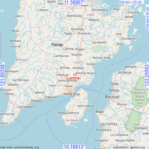
Lucena GPS coordinates[2]
10° 52' 45.84" North, 122° 35' 48.12" East
| Map corner | latitude | longitude |
|---|---|---|
| Upper-left | 11.56907°, | 121.89358° |
| Center: | 10.8794°, | 122.5967° |
| Lower-right: | 10.18813°, | 123.29983° |
| Map W x H: | 153.5×153.5 km | = 95.4×95.4mi |
| max Lat: | 20.78733° ⇑58.5% North |
| Lucena: | 10.8794° |
| min Lat: | ⇓41.5% South 4.65442° |
| min Long | Lucena | max Long |
| 117.04868° | 122.5967° | 126.58417° |
| W 47%⇐ | ⇒53% E |
Elevation
Elevation of Lucena is 22 m = 72 ft, and this is 65.9 m = 216 ft below average elevation for this country.
| Max E: |
2262 m = 7421 ft | 51.8% |
| Avg. | 87.9 m = 288 ft | |
| Lucena | 22 m = 72 ft | |
Min E: |
-2 m = -7 ft | 48.2% |
See also: Philippines elevation on elevation.city.
Geographical zone
Lucena is located in North Torrid zone (between Equator and Tropic of Cancer). Distance of Equator is 1209.7 km =751.7 mi to South.| Distance of | km | miles | from Lucena |
|---|---|---|---|
| North Pole | 8797.4 | 5466.4 | to North |
| Arctic Circle | 6191.5 | 3847.2 | to North |
| Tropic Cancer | 1396.2 | 867.6 | to North |
| Equator | 1209.7 | 751.7 | to South |


Nearby cities:
15 places around Lucena: (largest is in red/bold)
• Cabilauan
7 km =4.3 mi,  78°
78°
• Cabugao
9.6 km =6 mi,  216°
216°
• Igang
6.1 km =3.8 mi,  48°
48°
• Jalaud
6.2 km =3.9 mi,  129°
129°
• Jamabalod
2.7 km =1.7 mi,  91°
91°
• Kabilauan
3.3 km =2.1 mi,  231°
231°
• Leganes
10.3 km =6.4 mi,  184°
184°
• Mina
6.3 km =3.9 mi,  337°
337°
• Monpon
5.8 km =3.6 mi, 51°
• Pasil
4.8 km =3 mi,  162°
162°
• Pototan
8.3 km =5.2 mi,  30°
30°
• Santa Barbara
9.2 km =5.7 mi, 227°
• Tiring
10.4 km =6.5 mi,  251°
251°
• Tumcon Ilawod
8.7 km =5.4 mi,  61°
61°
• Zarraga
6.8 km =4.2 mi,  169°
169°
Sources, notices
• [Note1] Compared only with cities in Philippines existing in our database
• [Src1] Map data: © OpenStreetMap contributors (CC-BY-SA)
• [Src2] Other city data from geonames.org with taken over terms of usage.
• [Src3] Geographical zone / Annual Mean Temperature by Robert A. Rohde @ Wikipedia
