Hapao geodata
Hapao (Cordillera) is a populated place; located in Philippines in Asia/Manila (GMT+8) time zone. With population of 2,188 people, there are 3913 cities with bigger population in this country. Compared to other cities in Philippines, 92.8% of cities are located further ↓South; 76% of cities are located further →East and 98.9% of cities have lower elevation than Hapao. Note1


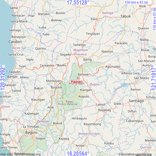
Hapao GPS coordinates[2]
16° 52' 46.776" North, 121° 0' 57.744" East
| Map corner | latitude | longitude |
|---|---|---|
| Upper-left | 17.55128°, | 120.31292° |
| Center: | 16.87966°, | 121.01604° |
| Lower-right: | 16.20564°, | 121.71917° |
| Map W x H: | 149.6×149.6 km | = 93×93mi |
| max Lat: | 20.78733° ⇑7.2% North |
| Hapao: | 16.87966° |
| min Lat: | ⇓92.8% South 4.65442° |
| min Long | Hapao | max Long |
| 117.04868° | 121.01604° | 126.58417° |
| W 24%⇐ | ⇒76% E |
Elevation
Elevation of Hapao is 932 m = 3058 ft, and this is 844.1 m = 2769 ft above average elevation for this country.
| Max E: |
2262 m = 7421 ft | 1.1% |
| Hapao | 932 m 3058 ft | |
| Avg. | 87.9 m = 288 ft | |
Min E: |
-2 m = -7 ft | 98.9% |
See also: Philippines elevation on elevation.city.
Geographical zone
Hapao is located in North Torrid zone (between Equator and Tropic of Cancer). Distance of this Northern Tropic circle is 729.1 km =453 mi to North.| Distance of | km | miles | from Hapao |
|---|---|---|---|
| North Pole | 8130.2 | 5051.9 | to North |
| Arctic Circle | 5524.3 | 3432.6 | to North |
| Tropic Cancer | 729.1 | 453 | to North |
| Equator | 1876.8 | 1166.2 | to South |


Nearby cities:
15 places around Hapao: (largest is in red/bold)
• Baculongan
21.4 km =13.3 mi,  245°
245°
• Baguinge
14.9 km =9.3 mi,  139°
139°
• Banaue
6.2 km =3.9 mi,  52°
52°
• Bangao
19.8 km =12.3 mi, 250°
• Barlig
19.9 km =12.4 mi,  28°
28°
• Bauko
20 km =12.4 mi,  307°
307°
• Bocos
6.8 km =4.2 mi,  40°
40°
• Bulalacao
22.6 km =14 mi,  257°
257°
• Guinsadan
18.3 km =11.4 mi,  300°
300°
• Kiangan
13.7 km =8.5 mi,  147°
147°
• Lagawe
14.1 km =8.8 mi,  128°
128°
• Monamon
14.1 km =8.8 mi,  271°
271°
• Sabangan
17 km =10.6 mi,  324°
324°
• Sadsadan
17 km =10.6 mi,  290°
290°
• Tabio
23.2 km =14.4 mi, 261°
Sources, notices
• [Note1] Compared only with cities in Philippines existing in our database
• [Src1] Map data: © OpenStreetMap contributors (CC-BY-SA)
• [Src2] Other city data from geonames.org with taken over terms of usage.
• [Src3] Geographical zone / Annual Mean Temperature by Robert A. Rohde @ Wikipedia
