Lagawe geodata
Lagawe (Cordillera) is a seat of a second-order administrative division; located in Philippines in Asia/Manila (GMT+8) time zone. With population of 6,819 people, there are 918 cities with bigger population in this country. Compared to other cities in Philippines, 92.3% of cities are located further ↓South; 73.3% of cities are located further →East and 95.9% of cities have lower elevation than Lagawe. Note1


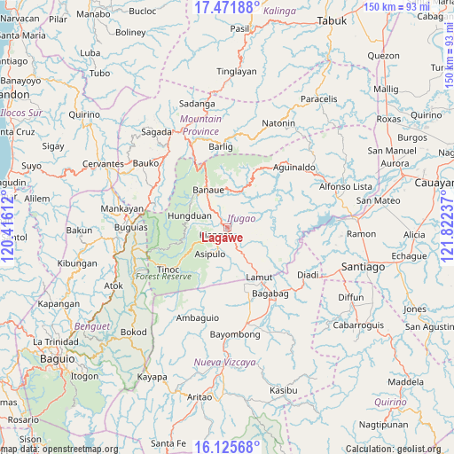
Lagawe GPS coordinates[2]
16° 47' 59.892" North, 121° 7' 9.264" East
| Map corner | latitude | longitude |
|---|---|---|
| Upper-left | 17.47188°, | 120.41612° |
| Center: | 16.79997°, | 121.11924° |
| Lower-right: | 16.12568°, | 121.82237° |
| Map W x H: | 149.7×149.7 km | = 93×93mi |
| max Lat: | 20.78733° ⇑7.7% North |
| Lagawe: | 16.79997° |
| min Lat: | ⇓92.3% South 4.65442° |
| min Long | Lagawe | max Long |
| 117.04868° | 121.11924° | 126.58417° |
| W 26.7%⇐ | ⇒73.3% E |
Elevation
Elevation of Lagawe is 490 m = 1608 ft, and this is 402.1 m = 1319 ft above average elevation for this country.
| Max E: |
2262 m = 7421 ft | 4.1% |
| Lagawe | 490 m 1608 ft | |
| Avg. | 87.9 m = 288 ft | |
Min E: |
-2 m = -7 ft | 95.9% |
See also: Philippines elevation on elevation.city.
Geographical zone
Lagawe is located in North Torrid zone (between Equator and Tropic of Cancer). Distance of this Northern Tropic circle is 737.9 km =458.5 mi to North.| Distance of | km | miles | from Lagawe |
|---|---|---|---|
| North Pole | 8139.1 | 5057.4 | to North |
| Arctic Circle | 5533.2 | 3438.2 | to North |
| Tropic Cancer | 737.9 | 458.5 | to North |
| Equator | 1868 | 1160.7 | to South |


Nearby cities:
15 places around Lagawe: (largest is in red/bold)
• Bagabag
25.8 km =16 mi,  146°
146°
• Baguinge
2.8 km =1.7 mi,  209°
209°
• Banaue
14 km =8.7 mi,  334°
334°
• Barlig
26.4 km =16.4 mi,  356°
356°
• Bintawan
26 km =16.2 mi,  163°
163°
• Bocos
15.5 km =9.6 mi, 334°
• Diadi
26.8 km =16.7 mi,  107°
107°
• Hapao
14.1 km =8.8 mi,  308°
308°
• Ibung
22.4 km =13.9 mi, 161°
• Kiangan
4.4 km =2.7 mi,  233°
233°
• Lamut
20.2 km =12.6 mi, 146°
• Monamon
26.8 km =16.7 mi,  290°
290°
• Tuao
27.8 km =17.3 mi, 147°
• Uddiawan
27 km =16.8 mi,  172°
172°
• Villa Verde
23.5 km =14.6 mi, 161°
Sources, notices
• [Note1] Compared only with cities in Philippines existing in our database
• [Src1] Map data: © OpenStreetMap contributors (CC-BY-SA)
• [Src2] Other city data from geonames.org with taken over terms of usage.
• [Src3] Geographical zone / Annual Mean Temperature by Robert A. Rohde @ Wikipedia
