Bocos geodata
Bocos (Cordillera) is a populated place; located in Philippines in Asia/Manila (GMT+8) time zone. With population of 2,428 people, there are 3415 cities with bigger population in this country. Compared to other cities in Philippines, 93.1% of cities are located further ↓South; 75% of cities are located further →East and 99.3% of cities have lower elevation than Bocos. Note1


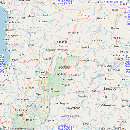
Bocos GPS coordinates[2]
16° 55' 35.256" North, 121° 3' 26.424" East
| Map corner | latitude | longitude |
|---|---|---|
| Upper-left | 17.59791°, | 120.35422° |
| Center: | 16.92646°, | 121.05734° |
| Lower-right: | 16.25261°, | 121.76047° |
| Map W x H: | 149.6×149.6 km | = 93×93mi |
| max Lat: | 20.78733° ⇑6.9% North |
| Bocos: | 16.92646° |
| min Lat: | ⇓93.1% South 4.65442° |
| min Long | Bocos | max Long |
| 117.04868° | 121.05734° | 126.58417° |
| W 25%⇐ | ⇒75% E |
Elevation
Elevation of Bocos is 1172 m = 3845 ft, and this is 1084.1 m = 3557 ft above average elevation for this country.
| Max E: |
2262 m = 7421 ft | 0.7% |
| Bocos | 1172 m 3845 ft | |
| Avg. | 87.9 m = 288 ft | |
Min E: |
-2 m = -7 ft | 99.3% |
See also: Philippines elevation on elevation.city.
Geographical zone
Bocos is located in North Torrid zone (between Equator and Tropic of Cancer). Distance of this Northern Tropic circle is 723.9 km =449.8 mi to North.| Distance of | km | miles | from Bocos |
|---|---|---|---|
| North Pole | 8125 | 5048.6 | to North |
| Arctic Circle | 5519.1 | 3429.4 | to North |
| Tropic Cancer | 723.9 | 449.8 | to North |
| Equator | 1882 | 1169.4 | to South |


Nearby cities:
15 places around Bocos: (largest is in red/bold)
• Baguinge
17.3 km =10.7 mi,  162°
162°
• Banaue
1.5 km =0.9 mi, 161°
• Bangao
25.9 km =16.1 mi,  243°
243°
• Barlig
13.3 km =8.3 mi,  21°
21°
• Bauko
21.4 km =13.3 mi,  289°
289°
• Betwagan
19.9 km =12.4 mi,  331°
331°
• Bontoc
19.8 km =12.3 mi, 334°
• Guinsadan
20.6 km =12.8 mi,  281°
281°
• Hapao
6.8 km =4.2 mi,  220°
220°
• Kiangan
17 km =10.6 mi,  169°
169°
• Lagawe
15.5 km =9.6 mi,  154°
154°
• Monamon
19.1 km =11.9 mi,  255°
255°
• Sabangan
16.6 km =10.3 mi,  301°
301°
• Sadsadan
20.3 km =12.6 mi,  272°
272°
• Sagada
24.3 km =15.1 mi,  316°
316°
Sources, notices
• [Note1] Compared only with cities in Philippines existing in our database
• [Src1] Map data: © OpenStreetMap contributors (CC-BY-SA)
• [Src2] Other city data from geonames.org with taken over terms of usage.
• [Src3] Geographical zone / Annual Mean Temperature by Robert A. Rohde @ Wikipedia
