Baguinge geodata
Baguinge (Cordillera) is a populated place; located in Philippines in Asia/Manila (GMT+8) time zone. With population of 2,078 people, there are 4105 cities with bigger population in this country. Compared to other cities in Philippines, 92.2% of cities are located further ↓South; 73.6% of cities are located further →East and 97% of cities have lower elevation than Baguinge. Note1


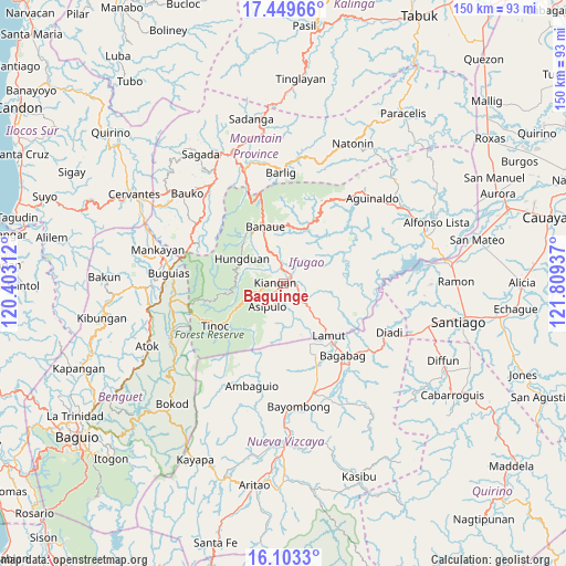
Baguinge GPS coordinates[2]
16° 46' 39.612" North, 121° 6' 22.464" East
| Map corner | latitude | longitude |
|---|---|---|
| Upper-left | 17.44966°, | 120.40312° |
| Center: | 16.77767°, | 121.10624° |
| Lower-right: | 16.1033°, | 121.80937° |
| Map W x H: | 149.7×149.7 km | = 93×93mi |
| max Lat: | 20.78733° ⇑7.8% North |
| Baguinge: | 16.77767° |
| min Lat: | ⇓92.2% South 4.65442° |
| min Long | Baguinge | max Long |
| 117.04868° | 121.10624° | 126.58417° |
| W 26.4%⇐ | ⇒73.6% E |
Elevation
Elevation of Baguinge is 596 m = 1955 ft, and this is 508.1 m = 1667 ft above average elevation for this country.
| Max E: |
2262 m = 7421 ft | 3% |
| Baguinge | 596 m 1955 ft | |
| Avg. | 87.9 m = 288 ft | |
Min E: |
-2 m = -7 ft | 97% |
See also: Philippines elevation on elevation.city.
Geographical zone
Baguinge is located in North Torrid zone (between Equator and Tropic of Cancer). Distance of this Northern Tropic circle is 740.4 km =460.1 mi to North.| Distance of | km | miles | from Baguinge |
|---|---|---|---|
| North Pole | 8141.6 | 5059 | to North |
| Arctic Circle | 5535.7 | 3439.7 | to North |
| Tropic Cancer | 740.4 | 460.1 | to North |
| Equator | 1865.5 | 1159.2 | to South |


Nearby cities:
15 places around Baguinge: (largest is in red/bold)
• Bagabag
24.7 km =15.3 mi,  140°
140°
• Banaue
15.8 km =9.8 mi,  342°
342°
• Bangao
28.7 km =17.8 mi,  279°
279°
• Bintawan
24.1 km =15 mi,  158°
158°
• Bocos
17.3 km =10.7 mi, 342°
• Diadi
27.5 km =17.1 mi,  102°
102°
• Hapao
14.9 km =9.3 mi,  319°
319°
• Ibung
20.6 km =12.8 mi, 155°
• Kiangan
2.2 km =1.4 mi,  265°
265°
• Lagawe
2.8 km =1.7 mi,  29°
29°
• Lamut
19.1 km =11.9 mi, 138°
• Monamon
26.5 km =16.5 mi,  296°
296°
• Tuao
26.5 km =16.5 mi, 142°
• Uddiawan
24.8 km =15.4 mi,  168°
168°
• Villa Verde
21.7 km =13.5 mi, 156°
Sources, notices
• [Note1] Compared only with cities in Philippines existing in our database
• [Src1] Map data: © OpenStreetMap contributors (CC-BY-SA)
• [Src2] Other city data from geonames.org with taken over terms of usage.
• [Src3] Geographical zone / Annual Mean Temperature by Robert A. Rohde @ Wikipedia
